A service to auto provision devices in Aruba Central based on the Geo-IP location

Overview

Location Based Provisioning Service for Aruba Central

A service to auto provision devices in Aruba Central based on the Geo-IP location

GAPS

Geo-IP auto provisioning service (GAPS) will auto assign any new AP to a group in Central based on the location of the device.

How It Works:

  • New AP is plugged in and automatically connects to Aruba Central.
  • Central via webhook posts a message to GAPS which then does a REST API call to Central for AP details.
  • The details are parsed for the public IP. GAPS makes an API call to a public GEO IP service which return the physical location of the installed AP.
  • The location data parsed for the two letter state code. This is checked against a local dictionary that maps the state to a group in Central (IE East-Group / West-Group).
  • GAPS then sends the group info to Central and provisions the AP into the proper group.

First Steps:

  1. Log into Aruba Central from the Account Home page:
    • API Gateway > System Apps & Tokens > Create a new key
    • Webhooks > Click the + sign > Enter the URL where the GAPS service will be posted "https://your-server.com/webhook"
  2. Launch the Network Dashboard:
    • Global > Alerts & Events > Config
    • Under Access Point > Enable AP Detect > Select the Webhook for GAPS

Install Instructions:

  1. Copy the files to host
  2. Open location_mapping.py
    • Match the two letter state code to the Central Group
    • Add a Group for the default for any Geo-IP locations that don't match
  3. Open dockerfile and add the Aruba Central Credentials
> ENV [email protected]  
> ENV PASSWORD=xxxxxxxxxx  
> ENV CLIENT_ID=xxxxxxxxxx  
> ENV CLIENT_SECRET=xxxxxxxxxx  
> ENV CUSTOMER_ID=xxxxxxxxxx  
> ENV BASE_URL=https://apigw-prod2.central.arubanetworks.com   
> ENV WEBHOOK_TOKEN=xxxxxxxxxx  
  1. Create the container "docker build -t gaps:latest ."
  2. Start the container "docker run -p 5000:5000 gaps"

This container includes gunicorn web-server, modify the wsgi config as needed.

Question - Feel free to contact me:
#(c) 2021 Will Smith - [email protected]

You might also like...
Imports VZD (Latvian State Land Service) open data into postgis enabled database

Python script main.py downloads and imports Latvian addresses into PostgreSQL database. Data contains parishes, counties, cities, towns, and streets.

Summary statistics of geospatial raster datasets based on vector geometries.

rasterstats rasterstats is a Python module for summarizing geospatial raster datasets based on vector geometries. It includes functions for zonal stat

Raster-based Spatial Analysis for Python

🌍 xarray-spatial: Raster-Based Spatial Analysis in Python πŸ“ Fast, Accurate Python library for Raster Operations ⚑ Extensible with Numba ⏩ Scalable w

Constraint-based geometry sketcher for blender

Geometry Sketcher Constraint-based sketcher addon for Blender that allows to create precise 2d shapes by defining a set of geometric constraints like

Spatial Interpolation Toolbox is a Python-based GUI that is able to interpolate spatial data in vector format.

Spatial Interpolation Toolbox This is the home to Spatial Interpolation Toolbox, a graphical user interface (GUI) for interpolating geographic vector

h3-js provides a JavaScript version of H3, a hexagon-based geospatial indexing system.

h3-js The h3-js library provides a pure-JavaScript version of the H3 Core Library, a hexagon-based geographic grid system. It can be used either in No

GebPy is a Python-based, open source tool for the generation of geological data of minerals, rocks and complete lithological sequences.

GebPy is a Python-based, open source tool for the generation of geological data of minerals, rocks and complete lithological sequences. The data can be generated randomly or with respect to user-defined constraints, for example a specific element concentration within minerals and rocks or the order of units within a complete lithological profile.

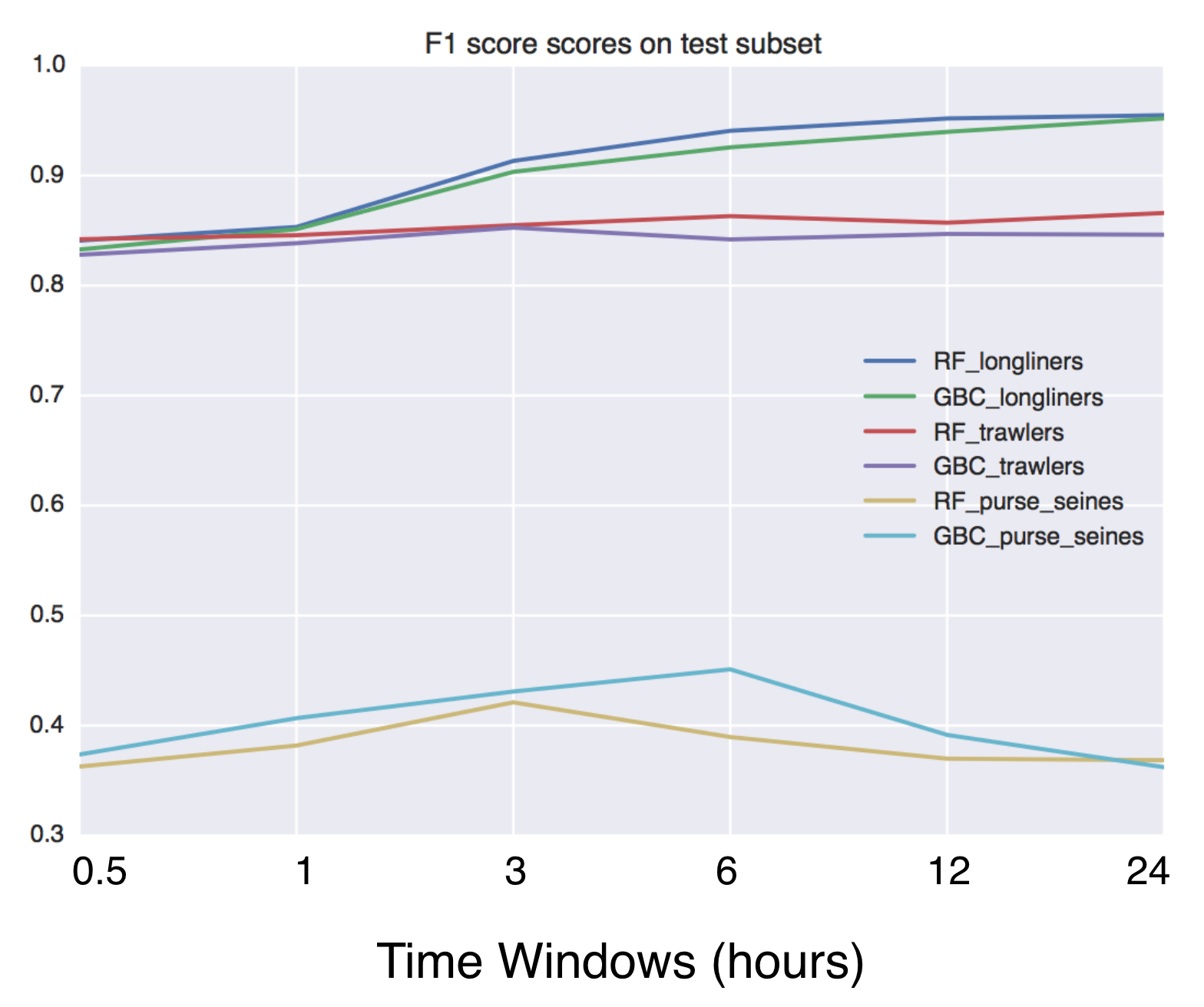
Using Global fishing watch's data to build a machine learning model that can identify illegal fishing and poaching activities through satellite and geo-location data.

Using Global fishing watch's data to build a machine learning model that can identify illegal fishing and poaching activities through satellite and geo-location data.

Auto Liker, Auto Reaction, Auto Comment, Auto Follower Tool. RajeLiker Credit Hacker.

Auto Liker, Auto Reaction, Auto Comment, Auto Follower Tool. RajeLiker Credit Hacker. Unlimited RajeLiker Credit Hack. Thanks To RajeLiker.

In this repository, I have developed an end to end Automatic speech recognition project. I have developed the neural network model for automatic speech recognition with PyTorch and used MLflow to manage the ML lifecycle, including experimentation, reproducibility, deployment, and a central model registry. A central task in drug discovery is searching, screening, and organizing large chemical databases
A central task in drug discovery is searching, screening, and organizing large chemical databases

A central task in drug discovery is searching, screening, and organizing large chemical databases. Here, we implement clustering on molecular similarity. We support multiple methods to provide a interactive exploration of chemical space.

BabelCalib: A Universal Approach to Calibrating Central Cameras. In ICCV (2021)

BabelCalib: A Universal Approach to Calibrating Central Cameras This repository contains the MATLAB implementation of the BabelCalib calibration frame

Distributed Grid Descent: an algorithm for hyperparameter tuning guided by Bayesian inference, designed to run on multiple processes and potentially many machines with no central point of control

Distributed Grid Descent: an algorithm for hyperparameter tuning guided by Bayesian inference, designed to run on multiple processes and potentially many machines with no central point of control.

The Django Leaflet Admin List package provides an admin list view featured by the map and bounding box filter for the geo-based data of the GeoDjango.

The Django Leaflet Admin List package provides an admin list view featured by the map and bounding box filter for the geo-based data of the GeoDjango. It requires a django-leaflet package.

A Transformer-Based Feature Segmentation and Region Alignment Method For UAV-View Geo-Localization

University1652-Baseline [Paper] [Slide] [Explore Drone-view Data] [Explore Satellite-view Data] [Explore Street-view Data] [Video Sample] [中文介绍] This

Weak-supervised Visual Geo-localization via Attention-based Knowledge Distillation

Weak-supervised Visual Geo-localization via Attention-based Knowledge Distillation Introduction WAKD is a PyTorch implementation for our ICPR-2022 pap

Apple Store Stock Notifier monitors the availability of selected Apple devices in selected Apple stores, and sends you a notification when devices are available!

Apple Store Stock Notifier This software will immediately send you a notification via Telegram when one of your coveted Apple Devices is available in

An electron application to check battery of bluetooth devices connected to linux devices.

bluetooth-battery-electron An electron application to check battery of bluetooth devices connected to linux devices. This project provides an electron

Pytorch implementation of Each Part Matters: Local Patterns Facilitate Cross-view Geo-localization https://arxiv.org/abs/2008.11646

[TCSVT] Each Part Matters: Local Patterns Facilitate Cross-view Geo-localization LPN [Paper] NEWs Prerequisites Python 3.6 GPU Memory = 8G Numpy 1.

Asynchronous Client for the worlds fastest in-memory geo-database Tile38

This is an asynchonous Python client for Tile38 that allows for fast and easy interaction with the worlds fastest in-memory geodatabase Tile38.

Ben 53 Dec 29, 2022
Evaluation of file formats in the context of geo-referenced 3D geometries.

Geo-referenced Geometry File Formats Classic geometry file formats as .obj, .off, .ply, .stl or .dae do not support the utilization of coordinate syst

Advanced Information Systems and Technology 11 Mar 2, 2022
Location field and widget for Django. It supports Google Maps, OpenStreetMap and Mapbox

django-location-field Let users pick locations using a map widget and store its latitude and longitude. Stable version: django-location-field==2.1.0 D

Caio Ariede 481 Dec 29, 2022
A simple python script that, given a location and a date, uses the Nasa Earth API to show a photo taken by the Landsat 8 satellite. The script must be executed on the command-line.

What does it do? Given a location and a date, it uses the Nasa Earth API to show a photo taken by the Landsat 8 satellite. The script must be executed

Caio 42 Nov 26, 2022
This is a simple python code to get IP address and its location using python

IP address & Location finder @DEV/ED : Pavan Ananth Sharma Dependencies: ip2geotools Note: use pip install ip2geotools to install this in your termin

Pavan Ananth Sharma 2 Jul 5, 2022
A bot that tweets info and location map for new bicycle parking added to OpenStreetMap within a GeoJSON boundary.

Bike parking tweepy bot app A twitter bot app that searches for bicycle parking added to OpenStreetMap. Relies on AWS Lambda/S3, Python3, Tweepy, Flas

Angelo Trivisonno 1 Dec 19, 2021
LicenseLocation - License Location With Python

LicenseLocation Hi,everyone! ❀ ?? ?? ?? ?? ?? This is my first project! βœ” Actual

The Bin 1 Jan 25, 2022
Mmdb-server - An open source fast API server to lookup IP addresses for their geographic location

mmdb-server mmdb-server is an open source fast API server to lookup IP addresses

Alexandre Dulaunoy 67 Nov 25, 2022
Centroids as a Service

Centroids! This application reads a valid geojson FeatureCollection and returns a valid geojson FeatureColleciton of centroids. In the output: All pro

Lyzi Diamond 20 Aug 29, 2021
Tile Map Service and OGC Tiles API for QGIS Server

Tiles API Add tiles API to QGIS Server Tiles Map Service API OGC Tiles API Tile Map Service API - TMS The TMS API provides these URLs: /tms/? to get i

3Liz 6 Dec 1, 2021