28 Repositories
Python TileDB-xarray Libraries

Synthetic data need to preserve the statistical properties of real data in terms of their individual behavior and (inter-)dependences
Synthetic data need to preserve the statistical properties of real data in terms of their individual behavior and (inter-)dependences. Copula and functional Principle Component Analysis (fPCA) are statistical models that allow these properties to be simulated (Joe 2014). As such, copula generated data have shown potential to improve the generalization of machine learning (ML) emulators (Meyer et al. 2021) or anonymize real-data datasets (Patki et al. 2016).
Stats, linear algebra and einops for xarray
xarray-einstats Stats, linear algebra and einops for xarray ⚠️ Caution: This project is still in a very early development stage Installation To instal

Download and process GOES-16 and GOES-17 data from NOAA's archive on AWS using Python.
Download and display GOES-East and GOES-West data GOES-East and GOES-West satellite data are made available on Amazon Web Services through NOAA's Big

Python for downloading model data (HRRR, RAP, GFS, NBM, etc.) from NOMADS, NOAA's Big Data Program partners (Amazon, Google, Microsoft), and the University of Utah Pando Archive System.
Python for downloading model data (HRRR, RAP, GFS, NBM, etc.) from NOMADS, NOAA's Big Data Program partners (Amazon, Google, Microsoft), and the University of Utah Pando Archive System.

Maximum Covariance Analysis in Python
xMCA | Maximum Covariance Analysis in Python The aim of this package is to provide a flexible tool for the climate science community to perform Maximu

TileDB-Py is a Python interface to the TileDB Storage Engine.
TileDB-Py TileDB-Py is a Python interface to the TileDB Storage Engine. Quick Links Installation Build Instructions TileDB Documentation Python API re
A lightweight interface for reading in output from the Weather Research and Forecasting (WRF) model into xarray Dataset
xwrf A lightweight interface for reading in output from the Weather Research and Forecasting (WRF) model into xarray Dataset. The primary objective of

A high-level plotting API for pandas, dask, xarray, and networkx built on HoloViews
hvPlot A high-level plotting API for the PyData ecosystem built on HoloViews. Build Status Coverage Latest dev release Latest release Docs What is it?
Schema validation for Xarray objects
xarray-schema Schema validation for Xarray installation This package is in the early stages of development. Install it from source: pip install git+gi

Digital Earth Australia notebooks and tools repository
Repository for Digital Earth Australia Jupyter Notebooks: tools and workflows for geospatial analysis with Open Data Cube and xarray

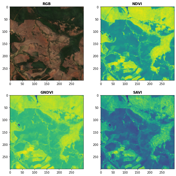
Awesome Spectral Indices in Python.
Awesome Spectral Indices in Python: Numpy | Pandas | GeoPandas | Xarray | Earth Engine | Planetary Computer | Dask GitHub: https://github.com/davemlz/
![Make GIFs from time-stacked xarray.DataArrays (time, [optional band], y, x), dead-simple.](https://github.com/gjoseph92/geogif/raw/main/docs/capecod.gif)
Make GIFs from time-stacked xarray.DataArrays (time, [optional band], y, x), dead-simple.
GeoGIF Make GIFs from time-stacked xarray.DataArrays (time, [optional band], y, x), dead-simple. from geogif import gif, dgif gif(data_array) dgif(das
Image Reading, Metadata Conversion, and Image Writing for Microscopy Images in Python
AICSImageIO Image Reading, Metadata Conversion, and Image Writing for Microscopy Images in Pure Python Features Supports reading metadata and imaging

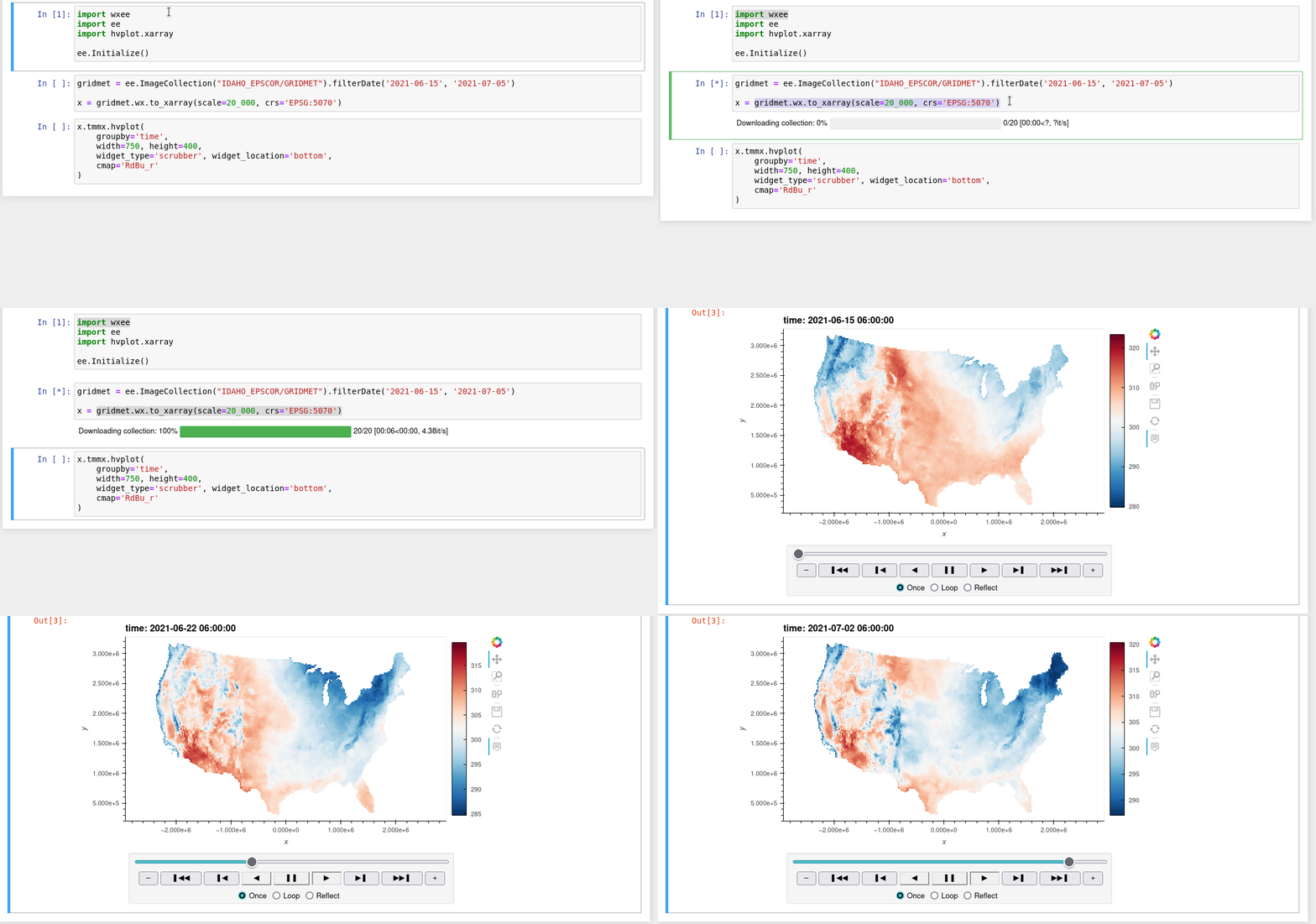
A Python interface between Earth Engine and xarray for processing weather and climate data
wxee What is wxee? wxee was built to make processing gridded, mesoscale time series weather and climate data quick and easy by integrating the data ca

A Python interface between Earth Engine and xarray
eexarray A Python interface between Earth Engine and xarray Description eexarray was built to make processing gridded, mesoscale time series data quic
Ingest and query genomic intervals from multiple BED files
Ingest and query genomic intervals from multiple BED files.
EOReader is a multi-satellite reader allowing you to open optical and SAR data.
Remote-sensing opensource python library reading optical and SAR sensors, loading and stacking bands, clouds, DEM and index.
Aggregating gridded data (xarray) to polygons
A package to aggregate gridded data in xarray to polygons in geopandas using area-weighting from the relative area overlaps between pixels and polygons.
Xarray backend to Copernicus Sentinel-1 satellite data products
xarray-sentinel WARNING: this product is a "technology preview" / pre-Alpha Xarray backend to explore and load Copernicus Sentinel-1 satellite data pr

Raster-based Spatial Analysis for Python
🌍 xarray-spatial: Raster-Based Spatial Analysis in Python 📍 Fast, Accurate Python library for Raster Operations ⚡ Extensible with Numba ⏩ Scalable w
Python package for earth-observing satellite data processing
Satpy The Satpy package is a python library for reading and manipulating meteorological remote sensing data and writing it to various image and data f

A TileDB backend for xarray.
TileDB-xarray This library provides a backend engine to xarray using the TileDB Storage Engine. Example usage: import xarray as xr dataset = xr.open_d
Turn a STAC catalog into a dask-based xarray
StackSTAC Turn a list of STAC items into a 4D xarray DataArray (dims: time, band, y, x), including reprojection to a common grid. The array is a lazy
Publish Xarray Datasets via a REST API.
Xpublish Publish Xarray Datasets via a REST API. Serverside: Publish a Xarray Dataset through a rest API ds.rest.serve(host="0.0.0.0", port=9000) Clie
Aggregating gridded data (xarray) to polygons
A package to aggregate gridded data in xarray to polygons in geopandas using area-weighting from the relative area overlaps between pixels and polygons. Check out the binder link above for a sample code run!
xarray: N-D labeled arrays and datasets
xarray is an open source project and Python package that makes working with labelled multi-dimensional arrays simple, efficient, and fun!

A high-level plotting API for pandas, dask, xarray, and networkx built on HoloViews
hvPlot A high-level plotting API for the PyData ecosystem built on HoloViews. Build Status Coverage Latest dev release Latest release Docs What is it?

A high-level plotting API for pandas, dask, xarray, and networkx built on HoloViews
hvPlot A high-level plotting API for the PyData ecosystem built on HoloViews. Build Status Coverage Latest dev release Latest release Docs What is it?