Program that shows all the details of the given IP address. Build with Python and ipinfo.io API

Overview

ip-details

This is a program that shows all the details of the given IP address. Build with Python and ipinfo.io API

Usage

To use this program, run the main Batch or Shell file, entering an IPv4 address as argument.

$ ip 1.1.1.1

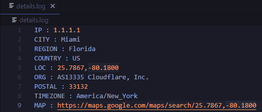
You can also add the --save or -s flag, to save the output to a file. The file will be named details.log, and will be stored inside the saves directory of the program (saves/details.log).

$ ip 1.1.1.1 --save

Or, if prefered:

$ ip 1.1.1.1 -s

Example

$ ip 1.1.1.1

IP : 1.1.1.1
CITY : Miami
REGION : Florida
COUNTRY : US
LOC : 25.7867,-80.1800
ORG : AS13335 Cloudflare, Inc.
POSTAL : 33132
TIMEZONE : America/New_York
MAP : https://maps.google.com/maps/search/25.7867,-80.1800

And with the save option:

$ ip 1.1.1.1 --save

IP : 1.1.1.1
CITY : Miami
REGION : Florida
COUNTRY : US
LOC : 25.7867,-80.1800
ORG : AS13335 Cloudflare, Inc.
POSTAL : 33132
TIMEZONE : America/New_York
MAP : https://maps.google.com/maps/search/25.7867,-80.1800

Data saved to saves/details.log

details.log file:

image

Requirements

Python programming language

Requests python library (pip install requests)
You might also like...
Tile Map Service and OGC Tiles API for QGIS Server

Tiles API Add tiles API to QGIS Server Tiles Map Service API OGC Tiles API Tile Map Service API - TMS The TMS API provides these URLs: /tms/? to get i

Mmdb-server - An open source fast API server to lookup IP addresses for their geographic location

mmdb-server mmdb-server is an open source fast API server to lookup IP addresses

OSMnx: Python for street networks. Retrieve, model, analyze, and visualize street networks and other spatial data from OpenStreetMap.

OSMnx OSMnx is a Python package that lets you download geospatial data from OpenStreetMap and model, project, visualize, and analyze real-world street

Python bindings and utilities for GeoJSON

geojson This Python library contains: Functions for encoding and decoding GeoJSON formatted data Classes for all GeoJSON Objects An implementation of

Python interface to PROJ (cartographic projections and coordinate transformations library)

pyproj Python interface to PROJ (cartographic projections and coordinate transformations library). Documentation Stable: http://pyproj4.github.io/pypr

Python bindings and utilities for GeoJSON

geojson This Python library contains: Functions for encoding and decoding GeoJSON formatted data Classes for all GeoJSON Objects An implementation of

python toolbox for visualizing geographical data and making maps

geoplotlib is a python toolbox for visualizing geographical data and making maps data = read_csv('data/bus.csv') geoplotlib.dot(data) geoplotlib.show(

 geemap - A Python package for interactive mapping with Google Earth Engine, ipyleaflet, and ipywidgets.
geemap - A Python package for interactive mapping with Google Earth Engine, ipyleaflet, and ipywidgets.

A Python package for interactive mapping with Google Earth Engine, ipyleaflet, and folium

Python interface to PROJ (cartographic projections and coordinate transformations library)

pyproj Python interface to PROJ (cartographic projections and coordinate transformations library). Documentation Stable: http://pyproj4.github.io/pypr

Owner
null
A simple python script that, given a location and a date, uses the Nasa Earth API to show a photo taken by the Landsat 8 satellite. The script must be executed on the command-line.

What does it do? Given a location and a date, it uses the Nasa Earth API to show a photo taken by the Landsat 8 satellite. The script must be executed

Caio 42 Nov 26, 2022
An API built to format given addresses using Python and Flask.

An API built to format given addresses using Python and Flask. About The API returns properly formatted data, i.e. removing duplicate fields, distingu

null 1 Feb 27, 2022
This is a simple python code to get IP address and its location using python

IP address & Location finder @DEV/ED : Pavan Ananth Sharma Dependencies: ip2geotools Note: use pip install ip2geotools to install this in your termin

Pavan Ananth Sharma 2 Jul 5, 2022
Python bindings to libpostal for fast international address parsing/normalization

pypostal These are the official Python bindings to https://github.com/openvenues/libpostal, a fast statistical parser/normalizer for street addresses

openvenues 651 Dec 16, 2022
Using Global fishing watch's data to build a machine learning model that can identify illegal fishing and poaching activities through satellite and geo-location data.

Using Global fishing watch's data to build a machine learning model that can identify illegal fishing and poaching activities through satellite and geo-location data.

Ayush Mishra 3 May 6, 2022
Build, deploy and extract satellite public constellations with one command line.

SatExtractor Build, deploy and extract satellite public constellations with one command line. Table of Contents About The Project Getting Started Stru

Frontier Development Lab 70 Nov 18, 2022
This program analizes films database with adresses, and creates a folium map with closest films to the coordinates

Films-map-project UCU CS lab 1.2, 1st year This program analizes films database with adresses, and creates a folium map with closest films to the coor

Artem Moskovets 1 Feb 9, 2022
Documentation and samples for ArcGIS API for Python

ArcGIS API for Python ArcGIS API for Python is a Python library for working with maps and geospatial data, powered by web GIS. It provides simple and

Esri 1.4k Dec 30, 2022
GeoIP Legacy Python API

MaxMind GeoIP Legacy Python Extension API Requirements Python 2.5+ or 3.3+ GeoIP Legacy C Library 1.4.7 or greater Installation With pip: $ pip instal

MaxMind 230 Nov 10, 2022
Python module to access the OpenCage geocoding API

OpenCage Geocoding Module for Python A Python module to access the OpenCage Geocoder. Build Status / Code Quality / etc Usage Supports Python 3.6 or n

OpenCage GmbH 57 Nov 1, 2022