QLUSTER is a relative orbit design tool for formation flying satellite missions and space rendezvous scenarios

Related tags

Geolocation QLUSTER
Overview

https://raw.githubusercontent.com/sammmlow/QLUSTER/main/gui/qluster_logo.png

Project: QLUSTER
Github: https://github.com/sammmlow/QLUSTER
Documents: https://example.com/
Version: 0.1 (Unstable)

docs license

Author: Samuel Y. W. Low

linkedin orcid

QLUSTER

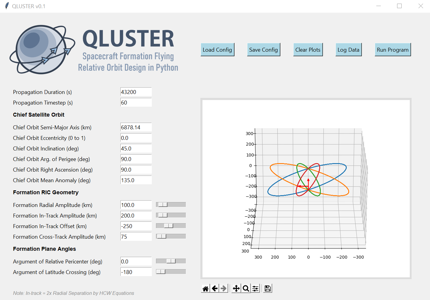
QLUSTER is a relative orbit design tool for formation flying satellite missions and space rendezvous scenarios, that I wrote in Python 3 for my own research and visualisation. It is currently unfinished (95%) but the core algorithm and app works. Here's an example snippet of the GUI where four deputy satellites are orbiting a single chief in LEO.

https://raw.githubusercontent.com/sammmlow/QLUSTER/main/gui/qluster_gui.png

I am open-sourcing it, as I would love to collaborate with you to improve on QLUSTER if you have any cool features to add-on in relation to the design, visualisation, and propagation of the relative astrodynamics!

To-Do List: Documentation, deputy orbit determination, logging of ephemeris etc.

Stretch-Goals: Relative orbit propagation for perturbed orbits, and computation of formation maintenance.


Installation and First Steps

First, clone this repository by running in your terminal (or Git Bash):

git clone https://github.com/sammmlow/QLUSTER.git

Then, just run the main qluster.py file in the main directory, and the GUI should pop up. Have fun!


Other Package Dependencies

To be written


Contact

If you have any queries feel free to reach out to me at:

[email protected]

linkedin orcid

Last Modified on 30-May-2021

You might also like...
framework for large-scale SAR satellite data processing

pyroSAR A Python Framework for Large-Scale SAR Satellite Data Processing The pyroSAR package aims at providing a complete solution for the scalable or

Satellite imagery for dummies.

felicette Satellite imagery for dummies. What can you do with this tool? TL;DR: Generate JPEG earth imagery from coordinates/location name with public

Xarray backend to Copernicus Sentinel-1 satellite data products

xarray-sentinel WARNING: this product is a "technology preview" / pre-Alpha Xarray backend to explore and load Copernicus Sentinel-1 satellite data pr

 LEOGPS - Satellite Navigation with GPS on Python!
LEOGPS - Satellite Navigation with GPS on Python!

LEOGPS is an open-source Python software which performs relative satellite navigation between two formation flying satellites, with the objective of high accuracy relative positioning. Specifically, LEOGPS solves for the double-differenced baseline (using float ambiguity resolution) between satellites flying in formation in Low Earth Orbit (LEO).

A package to fetch sentinel 2 Satellite data from Google.

Sentinel 2 Data Fetcher Installation Create a Virtual Environment and activate it. python3 -m venv venv . venv/bin/activate Install the Package via pi

Track International space station with python

NASA-ISS-tracker Track International space station with python Modules import json import turtle import urllib.request import time import webbrowser i

Tool to suck data from ArcGIS Server and spit it into PostgreSQL

chupaESRI About ChupaESRI is a Python module/command line tool to extract features from ArcGIS Server map services. Name? Think "chupacabra" or "Chupa

This tool reads the route of a hike and generates a table of iNaturalist observations along the trails.

This tool reads the route of a hike and generates a table of iNaturalist observations along the trails. It also shows the observations and the route of the hike on a map. Moreover, it saves waypoints of the iNaturalist observations for offline navigation with a GPS device or smartphone.

GebPy is a Python-based, open source tool for the generation of geological data of minerals, rocks and complete lithological sequences.

GebPy is a Python-based, open source tool for the generation of geological data of minerals, rocks and complete lithological sequences. The data can be generated randomly or with respect to user-defined constraints, for example a specific element concentration within minerals and rocks or the order of units within a complete lithological profile.

Comments
  • GUI Issue

    GUI Issue

    GUI is cutoff halfway as was observed in LEOGPS. Adding this issue to serve as a reminder.

    Windows 10, 150% size of text, apps and other items. 1920 x 1080 resolution.

    opened by ANDREWNGT 1
Owner
Samuel Low
🌌 Space 🚀 Orbits 📡 Tech 🌏 Earth 🌳 Nature 🐢 Life ♥️
Samuel Low
Google Maps keeps old satellite imagery around for a while – this tool collects what's available for a user-specified region in the form of a GIF.

google-maps-at-88-mph The folks maintaining Google Maps regularly update the satellite imagery it serves its users, but outdated versions of the image

Noah Doersing 111 Sep 27, 2022
Using Global fishing watch's data to build a machine learning model that can identify illegal fishing and poaching activities through satellite and geo-location data.

Using Global fishing watch's data to build a machine learning model that can identify illegal fishing and poaching activities through satellite and geo-location data.

Ayush Mishra 3 May 6, 2022
Search and download Copernicus Sentinel satellite images

sentinelsat Sentinelsat makes searching, downloading and retrieving the metadata of Sentinel satellite images from the Copernicus Open Access Hub easy

null 837 Dec 28, 2022
A utility to search, download and process Landsat 8 satellite imagery

Landsat-util Landsat-util is a command line utility that makes it easy to search, download, and process Landsat imagery. Docs For full documentation v

Development Seed 681 Dec 7, 2022
Download and process satellite imagery in Python using Sentinel Hub services.

Description The sentinelhub Python package allows users to make OGC (WMS and WCS) web requests to download and process satellite images within your Py

Sentinel Hub 659 Dec 23, 2022
EOReader is a multi-satellite reader allowing you to open optical and SAR data.

Remote-sensing opensource python library reading optical and SAR sensors, loading and stacking bands, clouds, DEM and index.

ICube-SERTIT 152 Dec 30, 2022
Build, deploy and extract satellite public constellations with one command line.

SatExtractor Build, deploy and extract satellite public constellations with one command line. Table of Contents About The Project Getting Started Stru

Frontier Development Lab 70 Nov 18, 2022
A simple python script that, given a location and a date, uses the Nasa Earth API to show a photo taken by the Landsat 8 satellite. The script must be executed on the command-line.

What does it do? Given a location and a date, it uses the Nasa Earth API to show a photo taken by the Landsat 8 satellite. The script must be executed

Caio 42 Nov 26, 2022
Calculate & view the trajectory and live position of any earth-orbiting satellite

satellite-visualization A cross-platform application to calculate & view the trajectory and live position of any earth-orbiting satellite in 3D. This

Space Technology and Astronomy Cell - Open Source Society 3 Jan 8, 2022
Python package for earth-observing satellite data processing

Satpy The Satpy package is a python library for reading and manipulating meteorological remote sensing data and writing it to various image and data f

PyTroll 882 Dec 27, 2022