YOLTv5 rapidly detects objects in arbitrarily large aerial or satellite images that far exceed the ~600×600 pixel size typically ingested by deep learning object detection frameworks

Related tags

Deep Learning yoltv5
Overview

YOLTv5

Alt text

YOLTv5 rapidly detects objects in arbitrarily large aerial or satellite images that far exceed the ~600×600 pixel size typically ingested by deep learning object detection frameworks.

YOLTv5 builds upon YOLT and SIMRDWN, and updates these frameworks to use the YOLOv5 version of the YOLO object detection family. This repository has generally similar performance to the Darknet-based YOLTv4 repository. For those users who prefer a PyTorch backend, however, we provide YOLTv5.

Below, we provide examples of how to use this repository with the open-source SpaceNet dataset.


Running YOLTv5


0. Installation (Preliminary)

YOLTv5 is built to execute on a GPU-enabled machine.

cd yoltv5/yolov5
pip install -r requirements.txt 

# update with geo packages
conda install -c conda-forge gdal
conda install -c conda-forge osmnx=0.12 
conda install  -c conda-forge scikit-image
conda install  -c conda-forge statsmodels
pip install torchsummary
pip install utm
pip install numba
pip install jinja2==2.10

1. Train

Training preparation is accomplished via prep_train.py. To train a model, run:

cd /yoltv5
python yolov5/train.py --img 640 --batch 16 --epochs 100 --data yoltv5_train_vehicles_8cat.yaml --weights yolov5l.pt

2. Test

Simply edit yoltv5_test_vehicles_8cat.yaml to point to the appropriate locations, then run the test.sh script:

cd yoltv5
./test.sh ../configs/yoltv5_test_vehicles_8cat.yaml

Outputs will look something like the figure below:

Alt text

You might also like...
A public available dataset for road boundary detection in aerial images

Topo-boundary This is the official github repo of paper Topo-boundary: A Benchmark Dataset on Topological Road-boundary Detection Using Aerial Images

Official code of the paper
Official code of the paper "ReDet: A Rotation-equivariant Detector for Aerial Object Detection" (CVPR 2021)

ReDet: A Rotation-equivariant Detector for Aerial Object Detection ReDet: A Rotation-equivariant Detector for Aerial Object Detection (CVPR2021), Jiam

[CVPR2021] UAV-Human: A Large Benchmark for Human Behavior Understanding with Unmanned Aerial Vehicles

UAV-Human Official repository for CVPR2021: UAV-Human: A Large Benchmark for Human Behavior Understanding with Unmanned Aerial Vehicle Paper arXiv Res

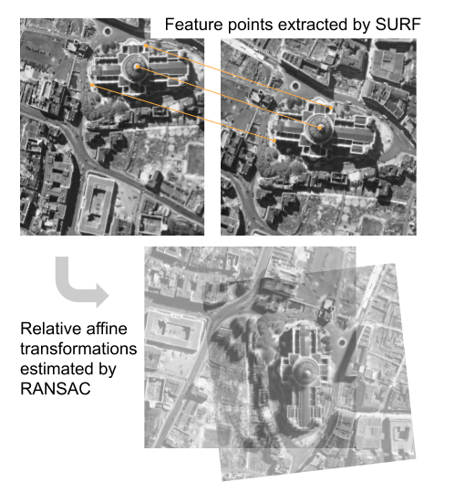
An algorithm that handles large-scale aerial photo co-registration, based on SURF, RANSAC and PyTorch autograd.

An algorithm that handles large-scale aerial photo co-registration, based on SURF, RANSAC and PyTorch autograd.

A vision library for performing sliced inference on large images/small objects

SAHI: Slicing Aided Hyper Inference A vision library for performing sliced inference on large images/small objects Overview Object detection and insta

Pixel-level Crack Detection From Images Of Levee Systems : A Comparative Study

PIXEL-LEVEL CRACK DETECTION FROM IMAGES OF LEVEE SYSTEMS : A COMPARATIVE STUDY G

moving object detection for satellite videos.

DSFNet: Dynamic and Static Fusion Network for Moving Object Detection in Satellite Videos Algorithm Introduction DSFNet: Dynamic and Static Fusion Net

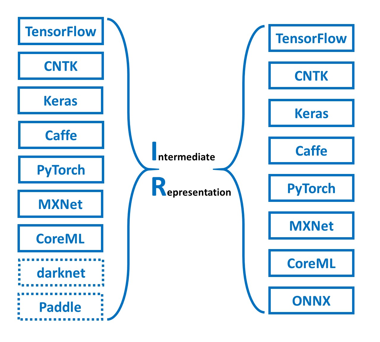
MMdnn is a set of tools to help users inter-operate among different deep learning frameworks. E.g. model conversion and visualization. Convert models between Caffe, Keras, MXNet, Tensorflow, CNTK, PyTorch Onnx and CoreML.

MMdnn MMdnn is a comprehensive and cross-framework tool to convert, visualize and diagnose deep learning (DL) models. The "MM" stands for model manage

Bulk2Space is a spatial deconvolution method based on deep learning frameworks

Bulk2Space Spatially resolved single-cell deconvolution of bulk transcriptomes using Bulk2Space Bulk2Space is a spatial deconvolution method based on

Comments
  • No module named 'eval'

    No module named 'eval'

    I am trying to run yoltv5 on Anaconda - Windows and using jupyter notebook. ran the requirements.txt file and followed the readme. I was able to train yoltv5. The code filled the ../runs/train/ directory

    However, I tried the test script !python test.py C:\Users\Documents\Projects\code\yoltv5\configs\test.yaml and got an error

    Traceback (most recent call last): File "C:\Users\Documents\Projects\code\yoltv5\yoltv5\test.py", line 53, in import eval ModuleNotFoundError: No module named 'eval'

    I couldn't find an eval.py file, what am I missing ?

    Thanks in advance

    opened by vmve 0
  • How did you switch the detection framework of YOLOV5 to YOLT?

    How did you switch the detection framework of YOLOV5 to YOLT?

    Thank you for your work. I have some questions about your project code: I looked at the model you called YoloV5 in the middle, but did not see the operation about model modification mentioned in your article (modifying the image network structure, such as modifying the Stride size, upsampling the image, and Ensemble). The most important thing is that you do not read the model. yaml configuration file like YOLOv5, how did you switch the detection framework of YOLOV5 to YOLT?

    opened by Scheaven 0
  • Extract Spatial Coordinate

    Extract Spatial Coordinate

    How can i apply YOLOt on Geo Tiff satellite images, and extract the real x,y coordinate for the bounding box ?! Not just deal with the image an normal png or jpg image !

    opened by AhmedHefnawy 0
Owner
Adam Van Etten
Adam Van Etten
Aerial Imagery dataset for fire detection: classification and segmentation (Unmanned Aerial Vehicle (UAV))

Aerial Imagery dataset for fire detection: classification and segmentation using Unmanned Aerial Vehicle (UAV) Title FLAME (Fire Luminosity Airborne-b

null 79 Jan 6, 2023
Learning Calibrated-Guidance for Object Detection in Aerial Images

Learning Calibrated-Guidance for Object Detection in Aerial Images arxiv We propose a simple yet effective Calibrated-Guidance (CG) scheme to enhance

null 51 Sep 22, 2022
Tiny Object Detection in Aerial Images.

AI-TOD AI-TOD is a dataset for tiny object detection in aerial images. [Paper] [Dataset] Description AI-TOD comes with 700,621 object instances for ei

jwwangchn 116 Dec 30, 2022
DeepLM: Large-scale Nonlinear Least Squares on Deep Learning Frameworks using Stochastic Domain Decomposition (CVPR 2021)

DeepLM DeepLM: Large-scale Nonlinear Least Squares on Deep Learning Frameworks using Stochastic Domain Decomposition (CVPR 2021) Run Please install th

Jingwei Huang 130 Dec 2, 2022
🍅🍅🍅YOLOv5-Lite: lighter, faster and easier to deploy. Evolved from yolov5 and the size of model is only 1.7M (int8) and 3.3M (fp16). It can reach 10+ FPS on the Raspberry Pi 4B when the input size is 320×320~

YOLOv5-Lite:lighter, faster and easier to deploy Perform a series of ablation experiments on yolov5 to make it lighter (smaller Flops, lower memory, a

pogg 1.5k Jan 5, 2023
Tools to create pixel-wise object masks, bounding box labels (2D and 3D) and 3D object model (PLY triangle mesh) for object sequences filmed with an RGB-D camera.

Tools to create pixel-wise object masks, bounding box labels (2D and 3D) and 3D object model (PLY triangle mesh) for object sequences filmed with an RGB-D camera. This project prepares training and testing data for various deep learning projects such as 6D object pose estimation projects singleshotpose, as well as object detection and instance segmentation projects.

null 305 Dec 16, 2022
a practicable framework used in Deep Learning. So far UDL only provide DCFNet implementation for the ICCV paper (Dynamic Cross Feature Fusion for Remote Sensing Pansharpening)

UDL UDL is a practicable framework used in Deep Learning (computer vision). Benchmark codes, results and models are available in UDL, please contact @

Xiao Wu 11 Sep 30, 2022
A large dataset of 100k Google Satellite and matching Map images, resembling pix2pix's Google Maps dataset.

Larger Google Sat2Map dataset This dataset extends the aerial ⟷ Maps dataset used in pix2pix (Isola et al., CVPR17). The provide script download_sat2m

null 34 Dec 28, 2022
An image base contains 490 images for learning (400 cars and 90 boats), and another 21 images for testingAn image base contains 490 images for learning (400 cars and 90 boats), and another 21 images for testing

SVM Données Une base d’images contient 490 images pour l’apprentissage (400 voitures et 90 bateaux), et encore 21 images pour fait des tests. Prétrait

Achraf Rahouti 3 Nov 30, 2021