Implementation of the pix2pix model on satellite images

Overview

This repo shows how to implement and use the pix2pix GAN model for image to image translation. The model is demonstrated on satellite images, and the purpose is to convert the sattelite images to map images.


The Model

The pix2pix model is composed from a generator and discriminator. The purpose of the generator is to convert the original image to a new image that is similar to target image - in our case convert a sattelite image to a street maps image. The Discriminator goal is to detect which of the images are a generated images and which of them are actually the target images. In that way, the generator and discriminator are competing each other, result in a model that learnes the mathematical mapping of the input sattelite images to the street view images.

RTST

Generator architecture:

The input image is inserted into a the generator, which is made from a Unet convolution model. The Unet model is composed of encoder and decoder with a skips connection between them. The Unet architecture is describe in the following image:

RTST

The input image is inserted into the model, the encoder module is composed of several convolution layers that shrinks the original image to the basic image feauture. The decoder module is then reconstruct the image to the original image size using a transposed convolutions layers. A skip connection between the encoder and decoder is used in each layer of the the encoder-decoter convolutions in order to preserve more information of the original image. The idea behind using this architecure is very intiutive - we want to transform image of sattelite maps to an image of a street maps. Therfore we want to convert the image to another image, but we want to keep the basic structure of the image. The Unet encoder decoder module allows us to acheieve that.


Discriminator architecture:

The Discriminator receives the images and shrinks it to a smaller image. It is doint that by using several convolution layers, each layers shrinks the image to a smaller size. The outputs is a smaller image, in our case it's a 30x30x1 image. Each pixel represent transformation of part of the image to a value between 0 1. The pixels value will represent the probability of the image slice to come from the real target. The method of converting the image to slices of smaller imagine in order to decide wheather this image is real or fake is called "Patch GAN". Transforming the image to patches of images gives better result then just converting the image to one outpat like was use in the original GAN.

RTST

The Loss Function

We will have two losses - one for the generator loss and one for the discriminator loss.

Then Generator loss is responsible to "fool" the discriminator and will try make it predict the generated image is real, and in the other hand it will also want to let the output image to be close to the target image. Therefore, the first part of the loss will be a Binary Crossentropy loss of the discriminator output for the generated images, together with labels of 1. This part will be responsiple for "tricking" the discriminator. The other part will be L1 loss - it will make the output to be symilar to the targets.

The Discriminator loss will also be combined from two parts - the first part is making the discriminator output to predict value close to 1 for all the images that came from the true targets, and the second part will make the discriminator predict value close to 0 for all the images that came from the generator. Both of the losses will be using Binary Crossentropy loss for this purpose.


Data Preperation

The dataset contains combined images of the sattelite images and it's correconponded street maps images. We will split this images to two images - the input images (the sattelite image) and target images (the street maps images). We will load the images to a pytorch DataLoader to make the training more efficient. This is how random input and target image looks like:

RTST


Results

We will inset the data into the models and run the training loop.

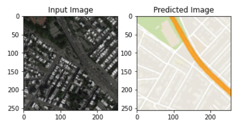
After 100 epochs, we get a result that is very similar to the target images. All the following example are taken from the test dataset, which the model wasn't train on.

Here are some of the results:

image image image

Summary

The model worked well and was able to generate images that are very similar to target images. It was able to generalize it very well to the testing set as well.

You might also like...
Amazon Forest Computer Vision: Satellite Image tagging code using PyTorch / Keras with lots of PyTorch tricks

Amazon Forest Computer Vision Satellite Image tagging code using PyTorch / Keras Here is a sample of images we had to work with Source: https://www.ka

Multiband spectro-radiometric satellite image analysis with K-means cluster algorithm

Multi-band Spectro Radiomertric Image Analysis with K-means Cluster Algorithm Overview Multi-band Spectro Radiomertric images are images comprising of

To propose and implement a multi-class classification approach to disaster assessment from the given data set of post-earthquake satellite imagery.

To propose and implement a multi-class classification approach to disaster assessment from the given data set of post-earthquake satellite imagery.

Space robot - (Course Project) Using the space robot to capture the target satellite that is disabled and spinning, then stabilize and fix it up

Space robot - (Course Project) Using the space robot to capture the target satellite that is disabled and spinning, then stabilize and fix it up

SatelliteSfM - A library for solving the satellite structure from motion problem

Satellite Structure from Motion Maintained by Kai Zhang. Overview This is a libr

Multi-Object Tracking in Satellite Videos with Graph-Based Multi-Task Modeling

TGraM Multi-Object Tracking in Satellite Videos with Graph-Based Multi-Task Modeling, Qibin He, Xian Sun, Zhiyuan Yan, Beibei Li, Kun Fu Abstract Rece

SatelliteNeRF - PyTorch-based Neural Radiance Fields adapted to satellite domain

SatelliteNeRF PyTorch-based Neural Radiance Fields adapted to satellite domain.

moving object detection for satellite videos.

DSFNet: Dynamic and Static Fusion Network for Moving Object Detection in Satellite Videos Algorithm Introduction DSFNet: Dynamic and Static Fusion Net

In this project we investigate the performance of the SetCon model on realistic video footage. Therefore, we implemented the model in PyTorch and tested the model on two example videos.

Contrastive Learning of Object Representations Supervisor: Prof. Dr. Gemma Roig Institutions: Goethe University CVAI - Computational Vision & Artifici

Owner
null
Image-to-Image Translation with Conditional Adversarial Networks (Pix2pix) implementation in keras

pix2pix-keras Pix2pix implementation in keras. Original paper: Image-to-Image Translation with Conditional Adversarial Networks (pix2pix) Paper Author

William Falcon 141 Dec 30, 2022
This repository contains several image-to-image translation models, whcih were tested for RGB to NIR image generation. The models are Pix2Pix, Pix2PixHD, CycleGAN and PointWise.

RGB2NIR_Experimental This repository contains several image-to-image translation models, whcih were tested for RGB to NIR image generation. The models

null 5 Jan 4, 2023
pix2pix in tensorflow.js

pix2pix in tensorflow.js This repo is moved to https://github.com/yining1023/pix2pix_tensorflowjs_lite See a live demo here: https://yining1023.github

Yining Shi 47 Oct 4, 2022
An image base contains 490 images for learning (400 cars and 90 boats), and another 21 images for testingAn image base contains 490 images for learning (400 cars and 90 boats), and another 21 images for testing

SVM Données Une base d’images contient 490 images pour l’apprentissage (400 voitures et 90 bateaux), et encore 21 images pour fait des tests. Prétrait

Achraf Rahouti 3 Nov 30, 2021
YOLTv5 rapidly detects objects in arbitrarily large aerial or satellite images that far exceed the ~600×600 pixel size typically ingested by deep learning object detection frameworks

YOLTv5 rapidly detects objects in arbitrarily large aerial or satellite images that far exceed the ~600×600 pixel size typically ingested by deep learning object detection frameworks.

Adam Van Etten 145 Jan 1, 2023
Code and model benchmarks for "SEVIR : A Storm Event Imagery Dataset for Deep Learning Applications in Radar and Satellite Meteorology"

NeurIPS 2020 SEVIR Code for paper: SEVIR : A Storm Event Imagery Dataset for Deep Learning Applications in Radar and Satellite Meteorology Requirement

USAF - MIT Artificial Intelligence Accelerator 46 Dec 15, 2022
Amazon Forest Computer Vision: Satellite Image tagging code using PyTorch / Keras with lots of PyTorch tricks

Amazon Forest Computer Vision Satellite Image tagging code using PyTorch / Keras Here is a sample of images we had to work with Source: https://www.ka

Mamy Ratsimbazafy 360 Dec 10, 2022
1st place solution to the Satellite Image Change Detection Challenge hosted by SenseTime

1st place solution to the Satellite Image Change Detection Challenge hosted by SenseTime

Lihe Yang 209 Jan 1, 2023
Train a deep learning net with OpenStreetMap features and satellite imagery.

DeepOSM Classify roads and features in satellite imagery, by training neural networks with OpenStreetMap (OSM) data. DeepOSM can: Download a chunk of

TrailBehind, Inc. 1.3k Nov 24, 2022
Satellite labelling tool for manual labelling of storm top features such as overshooting tops, above-anvil plumes, cold U/Vs, rings etc.

Satellite labelling tool About this app A tool for manual labelling of storm top features such as overshooting tops, above-anvil plumes, cold U/Vs, ri

Czech Hydrometeorological Institute - Satellite Department 10 Sep 14, 2022