51 Repositories
Python imagery Libraries

PyTorch implementation of U-TAE and PaPs for satellite image time series panoptic segmentation.
Panoptic Segmentation of Satellite Image Time Series with Convolutional Temporal Attention Networks (ICCV 2021) This repository is the official implem
An open software package to develop BCI based brain and cognitive computing technology for recognizing user's intention using deep learning
An open software package to develop BCI based brain and cognitive computing technology for recognizing user's intention using deep learning
Pytorch implement of 'Unmixing based PAN guided fusion network for hyperspectral imagery'
Pgnet There's a improved version compared with the publication in Tgrs with the modification in the deduction of the PDIN block: https://arxiv.org/abs
Python scripts for semi-automated morphometric analysis of atolls from Landsat satellite Imagery.
AtollGeoMorph Python scripts for semi-automated morphometric analysis of atolls from Landsat satellite Imagery. The python scripts included allow user
Kaggle DSTL Satellite Imagery Feature Detection
Kaggle DSTL Satellite Imagery Feature Detection
Semantic Segmentation for Aerial Imagery using Convolutional Neural Network
This repo has been deprecated because whole things are re-implemented by using Chainer and I did refactoring for many codes. So please check this newe
Multiple Object Extraction from Aerial Imagery with Convolutional Neural Networks
This is an implementation of Volodymyr Mnih's dissertation methods on his Massachusetts road & building dataset and my original methods that are publi

Raster Vision is an open source Python framework for building computer vision models on satellite, aerial, and other large imagery sets
Raster Vision is an open source Python framework for building computer vision models on satellite, aerial, and other large imagery sets (including obl

Generic ecosystem for feature extraction from aerial and satellite imagery
Note: Robosat is neither maintained not actively developed any longer by Mapbox. See this issue. The main developers (@daniel-j-h, @bkowshik) are no l

🛰️ Awesome Satellite Imagery Datasets
Awesome Satellite Imagery Datasets List of aerial and satellite imagery datasets with annotations for computer vision and deep learning. Newest datase

Download and process GOES-16 and GOES-17 data from NOAA's archive on AWS using Python.
Download and display GOES-East and GOES-West data GOES-East and GOES-West satellite data are made available on Amazon Web Services through NOAA's Big
Deep Learning pipeline for motor-imagery classification.
BCI-ToolBox 1. Introduction BCI-ToolBox is deep learning pipeline for motor-imagery classification. This repo contains five models: ShallowConvNet, De

A ninja python package that unifies the Google Earth Engine ecosystem.
A Python package that unifies the Google Earth Engine ecosystem. EarthEngine.jl | rgee | rgee+ | eemont GitHub: https://github.com/r-earthengine/ee_ex

To propose and implement a multi-class classification approach to disaster assessment from the given data set of post-earthquake satellite imagery.
To propose and implement a multi-class classification approach to disaster assessment from the given data set of post-earthquake satellite imagery.

CoANet: Connectivity Attention Network for Road Extraction From Satellite Imagery
CoANet: Connectivity Attention Network for Road Extraction From Satellite Imagery This paper (CoANet) has been published in IEEE TIP 2021. This code i

A Semantic Segmentation Network for Urban-Scale Building Footprint Extraction Using RGB Satellite Imagery
A Semantic Segmentation Network for Urban-Scale Building Footprint Extraction Using RGB Satellite Imagery This repository is the official implementati

Marine debris detection with commercial satellite imagery and deep learning.
Marine debris detection with commercial satellite imagery and deep learning. Floating marine debris is a global pollution problem which threatens mari

A python package that extends Google Earth Engine.
A python package that extends Google Earth Engine GitHub: https://github.com/davemlz/eemont Documentation: https://eemont.readthedocs.io/ PyPI: https:

Centroid-UNet is deep neural network model to detect centroids from satellite images.
Centroid UNet - Locating Object Centroids in Aerial/Serial Images Introduction Centroid-UNet is deep neural network model to detect centroids from Aer

🛰️ Scripts démontrant l'utilisation de l'imagerie RADARSAT-1 à partir d'un seau AWS | 🛰️ Scripts demonstrating the use of RADARSAT-1 imagery from an AWS bucket
🛰️ Scripts démontrant l'utilisation de l'imagerie RADARSAT-1 à partir d'un seau AWS | 🛰️ Scripts demonstrating the use of RADARSAT-1 imagery from an AWS bucket

🗂️ 🔍 Geospatial Data Management and Search API - Django Apps
Geospatial Data API in Django Resonant GeoData (RGD) is a series of Django applications well suited for cataloging and searching annotated geospatial
Multiband spectro-radiometric satellite image analysis with K-means cluster algorithm
Multi-band Spectro Radiomertric Image Analysis with K-means Cluster Algorithm Overview Multi-band Spectro Radiomertric images are images comprising of

eoplatform is a Python package that aims to simplify Remote Sensing Earth Observation by providing actionable information on a wide swath of RS platforms and provide a simple API for downloading and visualizing RS imagery
An Earth Observation Platform Earth Observation made easy. Report Bug | Request Feature About eoplatform is a Python package that aims to simplify Rem

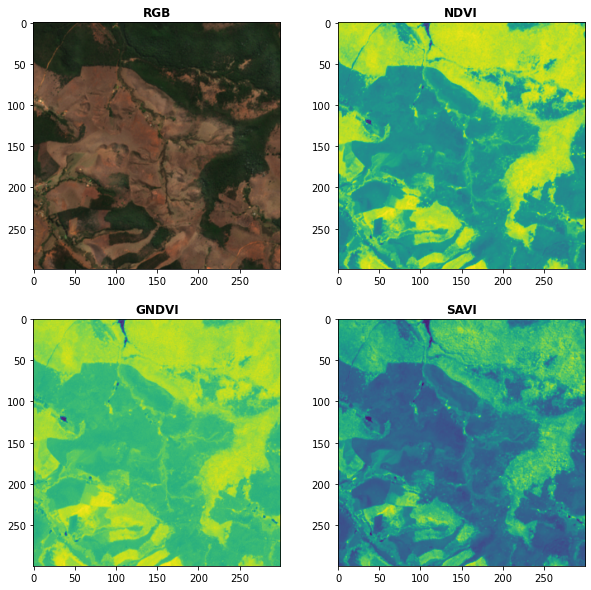
Awesome Spectral Indices in Python.
Awesome Spectral Indices in Python: Numpy | Pandas | GeoPandas | Xarray | Earth Engine | Planetary Computer | Dask GitHub: https://github.com/davemlz/

Build, deploy and extract satellite public constellations with one command line.
SatExtractor Build, deploy and extract satellite public constellations with one command line. Table of Contents About The Project Getting Started Stru
EODAG is a command line tool and a plugin-oriented Python framework for searching, aggregating results and downloading remote sensed images while offering a unified API for data access regardless of the data provider
EODAG (Earth Observation Data Access Gateway) is a command line tool and a plugin-oriented Python framework for searching, aggregating results and downloading remote sensed images while offering a unified API for data access regardless of the data provider
missing-pixel-filler is a python package that, given images that may contain missing data regions (like satellite imagery with swath gaps), returns these images with the regions filled.
Missing Pixel Filler This is the official code repository for the Missing Pixel Filler by SpaceML. missing-pixel-filler is a python package that, give

Official Implementation for "StyleCLIP: Text-Driven Manipulation of StyleGAN Imagery" (ICCV 2021 Oral)
StyleCLIP: Text-Driven Manipulation of StyleGAN Imagery (ICCV 2021 Oral) Run this model on Replicate Optimization: Global directions: Mapper: Check ou
Blender addon to generate better building models from satellite imagery.
Blender addon to generate better building models from satellite imagery.
Train a deep learning net with OpenStreetMap features and satellite imagery.
DeepOSM Classify roads and features in satellite imagery, by training neural networks with OpenStreetMap (OSM) data. DeepOSM can: Download a chunk of

A PyTorch implementation of Multi-digit Number Recognition from Street View Imagery using Deep Convolutional Neural Networks
SVHNClassifier-PyTorch A PyTorch implementation of Multi-digit Number Recognition from Street View Imagery using Deep Convolutional Neural Networks If

A ready-to-use curated list of Spectral Indices for Remote Sensing applications.
A ready-to-use curated list of Spectral Indices for Remote Sensing applications. GitHub: https://github.com/davemlz/awesome-ee-spectral-indices Docume

Change is Everywhere: Single-Temporal Supervised Object Change Detection in Remote Sensing Imagery (ICCV 2021)
Change is Everywhere Single-Temporal Supervised Object Change Detection in Remote Sensing Imagery by Zhuo Zheng, Ailong Ma, Liangpei Zhang and Yanfei
Experiments on Flood Segmentation on Sentinel-1 SAR Imagery with Cyclical Pseudo Labeling and Noisy Student Training
Flood Detection Challenge This repository contains code for our submission to the ETCI 2021 Competition on Flood Detection (Winning Solution #2). Acco

Google Maps keeps old satellite imagery around for a while – this tool collects what's available for a user-specified region in the form of a GIF.
google-maps-at-88-mph The folks maintaining Google Maps regularly update the satellite imagery it serves its users, but outdated versions of the image

FactSeg: Foreground Activation Driven Small Object Semantic Segmentation in Large-Scale Remote Sensing Imagery (TGRS)
FactSeg: Foreground Activation Driven Small Object Semantic Segmentation in Large-Scale Remote Sensing Imagery by Ailong Ma, Junjue Wang*, Yanfei Zhon

A collection of modules I have created to programmatically search for/download imagery from live cam feeds across the state of California.
A collection of modules that I have created to programmatically search for/download imagery from all publicly available live cam feeds across the state of California. In no way am I affiliated with any of these organizations and these modules/methods of gathering imagery are completely unofficial.

Aerial Imagery dataset for fire detection: classification and segmentation (Unmanned Aerial Vehicle (UAV))
Aerial Imagery dataset for fire detection: classification and segmentation using Unmanned Aerial Vehicle (UAV) Title FLAME (Fire Luminosity Airborne-b
EOReader is a multi-satellite reader allowing you to open optical and SAR data.
Remote-sensing opensource python library reading optical and SAR sensors, loading and stacking bands, clouds, DEM and index.
Xarray backend to Copernicus Sentinel-1 satellite data products
xarray-sentinel WARNING: this product is a "technology preview" / pre-Alpha Xarray backend to explore and load Copernicus Sentinel-1 satellite data pr
Download and process satellite imagery in Python using Sentinel Hub services.
Description The sentinelhub Python package allows users to make OGC (WMS and WCS) web requests to download and process satellite images within your Py
Satellite imagery for dummies.
felicette Satellite imagery for dummies. What can you do with this tool? TL;DR: Generate JPEG earth imagery from coordinates/location name with public
Stitch image tiles into larger composite TIFs
untiler Utility to take a directory of {z}/{x}/{y}.(jpg|png) tiles, and stitch into a scenetiff (tif w/ exact merc tile bounds). Future versions will

Color correction plugin for rasterio
rio-color A rasterio plugin for applying basic color-oriented image operations to geospatial rasters. Goals No heavy dependencies: rio-color is purpos

Histogram matching plugin for rasterio
rio-hist Histogram matching plugin for rasterio. Provides a CLI and python module for adjusting colors based on histogram matching in a variety of col
A utility to search, download and process Landsat 8 satellite imagery
Landsat-util Landsat-util is a command line utility that makes it easy to search, download, and process Landsat imagery. Docs For full documentation v

StyleCLIP: Text-Driven Manipulation of StyleGAN Imagery
StyleCLIP: Text-Driven Manipulation of StyleGAN Imagery
Search and download Copernicus Sentinel satellite images
sentinelsat Sentinelsat makes searching, downloading and retrieving the metadata of Sentinel satellite images from the Copernicus Open Access Hub easy

YOLOv5 in DOTA with CSL_label.(Oriented Object Detection)(Rotation Detection)(Rotated BBox)
YOLOv5_DOTA_OBB YOLOv5 in DOTA_OBB dataset with CSL_label.(Oriented Object Detection) Datasets and pretrained checkpoint Datasets : DOTA Pretrained Ch
Code and model benchmarks for "SEVIR : A Storm Event Imagery Dataset for Deep Learning Applications in Radar and Satellite Meteorology"
NeurIPS 2020 SEVIR Code for paper: SEVIR : A Storm Event Imagery Dataset for Deep Learning Applications in Radar and Satellite Meteorology Requirement

Official code of the paper "ReDet: A Rotation-equivariant Detector for Aerial Object Detection" (CVPR 2021)
ReDet: A Rotation-equivariant Detector for Aerial Object Detection ReDet: A Rotation-equivariant Detector for Aerial Object Detection (CVPR2021), Jiam