155 Repositories
Python spatial-imagery Libraries
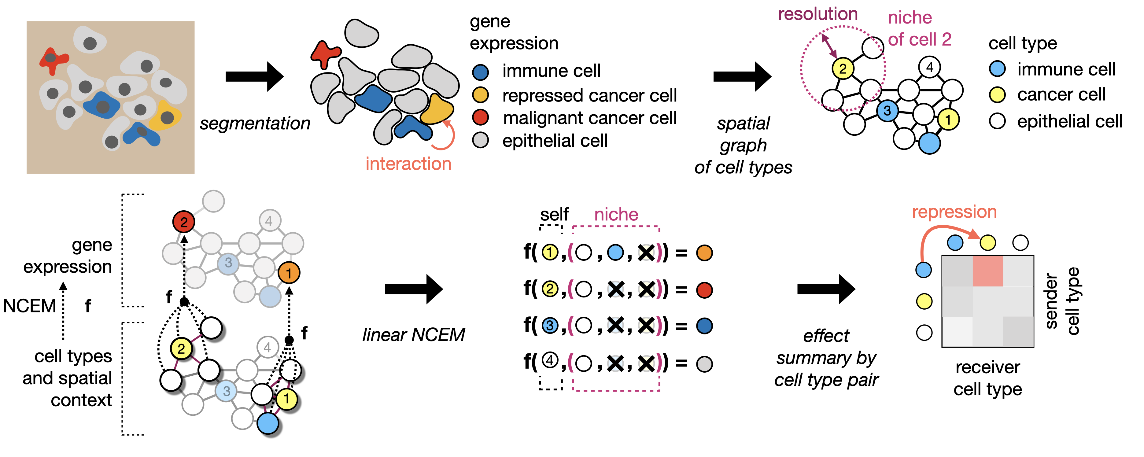
Learning cell communication from spatial graphs of cells
ncem Features Repository for the manuscript Fischer, D. S., Schaar, A. C. and Theis, F. Learning cell communication from spatial graphs of cells. 2021

Squidpy is a tool for the analysis and visualization of spatial molecular data.
Squidpy is a tool for the analysis and visualization of spatial molecular data. It builds on top of scanpy and anndata, from which it inherits modularity and scalability. It provides analysis tools that leverages the spatial coordinates of the data, as well as tissue images if available.

This is the official repo for TransFill: Reference-guided Image Inpainting by Merging Multiple Color and Spatial Transformations at CVPR'21. According to some product reasons, we are not planning to release the training/testing codes and models. However, we will release the dataset and the scripts to prepare the dataset.
TransFill-Reference-Inpainting This is the official repo for TransFill: Reference-guided Image Inpainting by Merging Multiple Color and Spatial Transf
CoSA: Scheduling by Constrained Optimization for Spatial Accelerators
CoSA is a scheduler for spatial DNN accelerators that generate high-performance schedules in one shot using mixed integer programming

The implementation of "Shuffle Transformer: Rethinking Spatial Shuffle for Vision Transformer"
Shuffle Transformer The implementation of "Shuffle Transformer: Rethinking Spatial Shuffle for Vision Transformer" Introduction Very recently, window-

The project is an official implementation of our paper "3D Human Pose Estimation with Spatial and Temporal Transformers".
3D Human Pose Estimation with Spatial and Temporal Transformers This repo is the official implementation for 3D Human Pose Estimation with Spatial and

A collection of modules I have created to programmatically search for/download imagery from live cam feeds across the state of California.
A collection of modules that I have created to programmatically search for/download imagery from all publicly available live cam feeds across the state of California. In no way am I affiliated with any of these organizations and these modules/methods of gathering imagery are completely unofficial.

Aerial Imagery dataset for fire detection: classification and segmentation (Unmanned Aerial Vehicle (UAV))
Aerial Imagery dataset for fire detection: classification and segmentation using Unmanned Aerial Vehicle (UAV) Title FLAME (Fire Luminosity Airborne-b

MSG-Transformer: Exchanging Local Spatial Information by Manipulating Messenger Tokens
MSG-Transformer Official implementation of the paper MSG-Transformer: Exchanging Local Spatial Information by Manipulating Messenger Tokens, by Jiemin
The repo of the preprinting paper "Labels Are Not Perfect: Inferring Spatial Uncertainty in Object Detection"
Inferring Spatial Uncertainty in Object Detection A teaser version of the code for the paper Labels Are Not Perfect: Inferring Spatial Uncertainty in
EOReader is a multi-satellite reader allowing you to open optical and SAR data.
Remote-sensing opensource python library reading optical and SAR sensors, loading and stacking bands, clouds, DEM and index.
MASA-SR: Matching Acceleration and Spatial Adaptation for Reference-Based Image Super-Resolution (CVPR2021)
MASA-SR Official PyTorch implementation of our CVPR2021 paper MASA-SR: Matching Acceleration and Spatial Adaptation for Reference-Based Image Super-Re

Text to Image Generation with Semantic-Spatial Aware GAN
text2image This repository includes the implementation for Text to Image Generation with Semantic-Spatial Aware GAN This repo is not completely. Netwo

Twins: Revisiting the Design of Spatial Attention in Vision Transformers
Twins: Revisiting the Design of Spatial Attention in Vision Transformers Very recently, a variety of vision transformer architectures for dense predic
Xarray backend to Copernicus Sentinel-1 satellite data products
xarray-sentinel WARNING: this product is a "technology preview" / pre-Alpha Xarray backend to explore and load Copernicus Sentinel-1 satellite data pr

Training code of Spatial Time Memory Network. Semi-supervised video object segmentation.
Training-code-of-STM This repository fully reproduces Space-Time Memory Networks Performance on Davis17 val set&Weights backbone training stage traini
This is the official implementation of 3D-CVF: Generating Joint Camera and LiDAR Features Using Cross-View Spatial Feature Fusion for 3D Object Detection, built on SECOND.
3D-CVF This is the official implementation of 3D-CVF: Generating Joint Camera and LiDAR Features Using Cross-View Spatial Feature Fusion for 3D Object

OpenMMLab's Next Generation Video Understanding Toolbox and Benchmark
Introduction English | 简体中文 MMAction2 is an open-source toolbox for video understanding based on PyTorch. It is a part of the OpenMMLab project. The m
中文空间语义理解评测
中文空间语义理解评测 最新消息 2021-04-10 🚩 排行榜发布: Leaderboard 2021-04-05 基线系统发布: SpaCE2021-Baseline 2021-04-05 开放数据提交: 提交结果 2021-04-01 开放报名: 我要报名 2021-04-01 数据集 pa
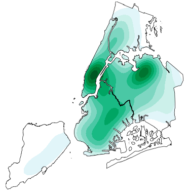
High-level geospatial data visualization library for Python.
geoplot: geospatial data visualization geoplot is a high-level Python geospatial plotting library. It's an extension to cartopy and matplotlib which m
Download and process satellite imagery in Python using Sentinel Hub services.
Description The sentinelhub Python package allows users to make OGC (WMS and WCS) web requests to download and process satellite images within your Py
Satellite imagery for dummies.
felicette Satellite imagery for dummies. What can you do with this tool? TL;DR: Generate JPEG earth imagery from coordinates/location name with public

Raster-based Spatial Analysis for Python
🌍 xarray-spatial: Raster-Based Spatial Analysis in Python 📍 Fast, Accurate Python library for Raster Operations ⚡ Extensible with Numba ⏩ Scalable w
Implementation of Trajectory classes and functions built on top of GeoPandas
MovingPandas MovingPandas implements a Trajectory class and corresponding methods based on GeoPandas. Visit movingpandas.org for details! You can run
Stitch image tiles into larger composite TIFs
untiler Utility to take a directory of {z}/{x}/{y}.(jpg|png) tiles, and stitch into a scenetiff (tif w/ exact merc tile bounds). Future versions will

Processing and interpolating spatial data with a twist of machine learning
Documentation | Documentation (dev version) | Contact | Part of the Fatiando a Terra project About Verde is a Python library for processing spatial da
Software for Advanced Spatial Econometrics
GeoDaSpace Software for Advanced Spatial Econometrics GeoDaSpace current version 1.0 (32-bit) Development environment: Mac OSX 10.5.x (32-bit) wxPytho
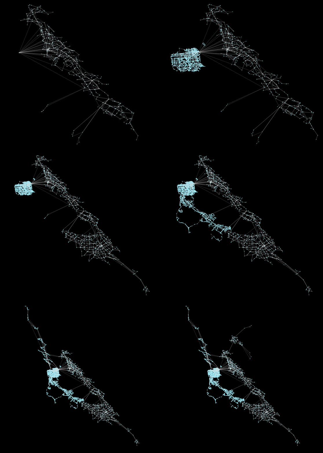
peartree: A library for converting transit data into a directed graph for sketch network analysis.
peartree 🍐 🌳 peartree is a library for converting GTFS feed schedules into a representative directed network graph. The tool uses Partridge to conve

Color correction plugin for rasterio
rio-color A rasterio plugin for applying basic color-oriented image operations to geospatial rasters. Goals No heavy dependencies: rio-color is purpos

Histogram matching plugin for rasterio
rio-hist Histogram matching plugin for rasterio. Provides a CLI and python module for adjusting colors based on histogram matching in a variety of col
Using SQLAlchemy with spatial databases
GeoAlchemy GIS Support for SQLAlchemy. Introduction GeoAlchemy is an extension of SQLAlchemy. It provides support for Geospatial data types at the ORM
A utility to search, download and process Landsat 8 satellite imagery
Landsat-util Landsat-util is a command line utility that makes it easy to search, download, and process Landsat imagery. Docs For full documentation v
OSMnx: Python for street networks. Retrieve, model, analyze, and visualize street networks and other spatial data from OpenStreetMap.
OSMnx OSMnx is a Python package that lets you download geospatial data from OpenStreetMap and model, project, visualize, and analyze real-world street

StyleCLIP: Text-Driven Manipulation of StyleGAN Imagery
StyleCLIP: Text-Driven Manipulation of StyleGAN Imagery
![[PyTorch] Official implementation of CVPR2021 paper](https://github.com/XuyangBai/PointDSC/raw/master/figures/pipeline.png)
[PyTorch] Official implementation of CVPR2021 paper "PointDSC: Robust Point Cloud Registration using Deep Spatial Consistency". https://arxiv.org/abs/2103.05465
PointDSC repository PyTorch implementation of PointDSC for CVPR'2021 paper "PointDSC: Robust Point Cloud Registration using Deep Spatial Consistency",

Spatial Action Maps for Mobile Manipulation (RSS 2020)
spatial-action-maps Update: Please see our new spatial-intention-maps repository, which extends this work to multi-agent settings. It contains many ne

The project is an official implementation of our paper "3D Human Pose Estimation with Spatial and Temporal Transformers".
3D Human Pose Estimation with Spatial and Temporal Transformers This repo is the official implementation for 3D Human Pose Estimation with Spatial and
Search and download Copernicus Sentinel satellite images
sentinelsat Sentinelsat makes searching, downloading and retrieving the metadata of Sentinel satellite images from the Copernicus Open Access Hub easy
A package built to support working with spatial data using open source python
EarthPy EarthPy makes it easier to plot and manipulate spatial data in Python. Why EarthPy? Python is a generic programming language designed to suppo

PySAL: Python Spatial Analysis Library Meta-Package
Python Spatial Analysis Library PySAL, the Python spatial analysis library, is an open source cross-platform library for geospatial data science with
Documentation and samples for ArcGIS API for Python
ArcGIS API for Python ArcGIS API for Python is a Python library for working with maps and geospatial data, powered by web GIS. It provides simple and

The open source code of SA-UNet: Spatial Attention U-Net for Retinal Vessel Segmentation.
SA-UNet: Spatial Attention U-Net for Retinal Vessel Segmentation(ICPR 2020) Overview This code is for the paper: Spatial Attention U-Net for Retinal V

Spatial Intention Maps for Multi-Agent Mobile Manipulation (ICRA 2021)
spatial-intention-maps This code release accompanies the following paper: Spatial Intention Maps for Multi-Agent Mobile Manipulation Jimmy Wu, Xingyua

YOLOv5 in DOTA with CSL_label.(Oriented Object Detection)(Rotation Detection)(Rotated BBox)
YOLOv5_DOTA_OBB YOLOv5 in DOTA_OBB dataset with CSL_label.(Oriented Object Detection) Datasets and pretrained checkpoint Datasets : DOTA Pretrained Ch
Code and model benchmarks for "SEVIR : A Storm Event Imagery Dataset for Deep Learning Applications in Radar and Satellite Meteorology"
NeurIPS 2020 SEVIR Code for paper: SEVIR : A Storm Event Imagery Dataset for Deep Learning Applications in Radar and Satellite Meteorology Requirement

Official PyTorch implementation of Spatial Dependency Networks.
Spatial Dependency Networks: Neural Layers for Improved Generative Image Modeling Đorđe Miladinović Aleksandar Stanić Stefan Bauer Jürgen Schmid

Unofficial implementation of "TTNet: Real-time temporal and spatial video analysis of table tennis" (CVPR 2020)
TTNet-Pytorch The implementation for the paper "TTNet: Real-time temporal and spatial video analysis of table tennis" An introduction of the project c

Official code of the paper "ReDet: A Rotation-equivariant Detector for Aerial Object Detection" (CVPR 2021)
ReDet: A Rotation-equivariant Detector for Aerial Object Detection ReDet: A Rotation-equivariant Detector for Aerial Object Detection (CVPR2021), Jiam
the code used for the preprint Embedding-based Instance Segmentation of Microscopy Images.
EmbedSeg Introduction This repository hosts the version of the code used for the preprint Embedding-based Instance Segmentation of Microscopy Images.

Implementation of the paper NAST: Non-Autoregressive Spatial-Temporal Transformer for Time Series Forecasting.
Non-AR Spatial-Temporal Transformer Introduction Implementation of the paper NAST: Non-Autoregressive Spatial-Temporal Transformer for Time Series For
data/code repository of "C2F-FWN: Coarse-to-Fine Flow Warping Network for Spatial-Temporal Consistent Motion Transfer"
C2F-FWN data/code repository of "C2F-FWN: Coarse-to-Fine Flow Warping Network for Spatial-Temporal Consistent Motion Transfer" (https://arxiv.org/abs/
Python implementation of cover trees, near-drop-in replacement for scipy.spatial.kdtree
This is a Python implementation of cover trees, a data structure for finding nearest neighbors in a general metric space (e.g., a 3D box with periodic

A Temporal Extension Library for PyTorch Geometric
Documentation | External Resources | Datasets PyTorch Geometric Temporal is a temporal (dynamic) extension library for PyTorch Geometric. The library
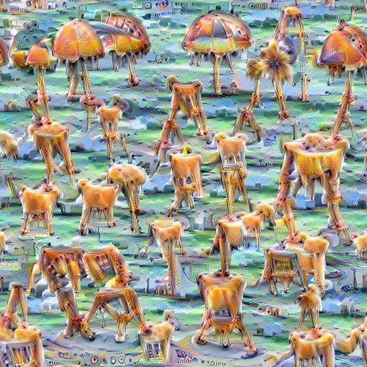
Quickly and easily create / train a custom DeepDream model
Dream-Creator This project aims to simplify the process of creating a custom DeepDream model by using pretrained GoogleNet models and custom image dat
Cartopy - a cartographic python library with matplotlib support
Cartopy is a Python package designed to make drawing maps for data analysis and visualisation easy. Table of contents Overview Get in touch License an