Real-time LIDAR-based Urban Road and Sidewalk detection for Autonomous Vehicles 🚗

Overview

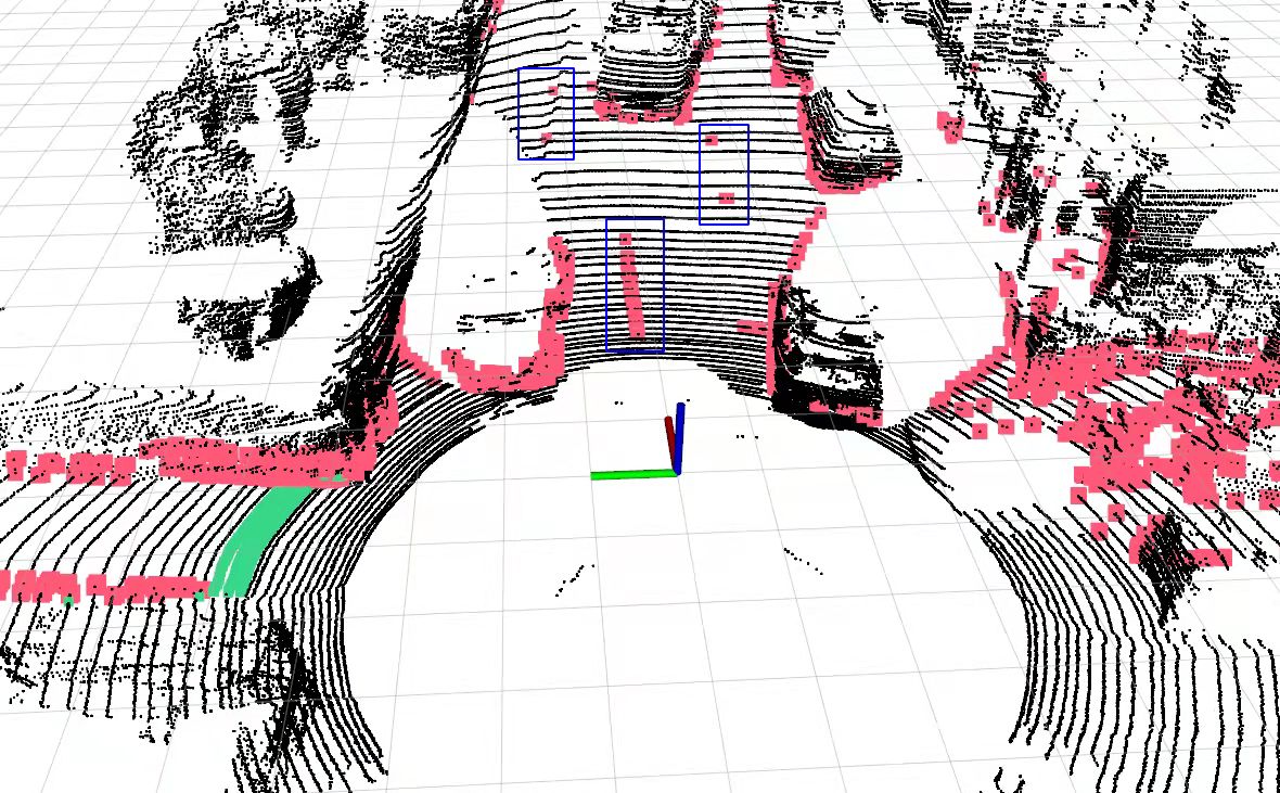
urban_road_filter: a real-time LIDAR-based urban road and sidewalk detection algorithm for autonomous vehicles

Dependency

  • ROS (tested with Kinetic and Melodic)
  • PCL

Install

Use the following commands to download and compile the package.

cd ~/catkin_ws/src
git clone https://github.com/jkk-research/urban_road_filter
catkin build urban_road_filter

Getting started

Cite & paper

If you use any of this code please consider citing the paper:


@Article{roadfilt2022horv,
    title = {Real-Time LIDAR-Based Urban Road and Sidewalk Detection for Autonomous Vehicles},
    author = {Horváth, Ernő and Pozna, Claudiu and Unger, Miklós},
    journal = {Sensors},
    volume = {22},
    year = {2022},
    number = {1},
    url = {https://www.mdpi.com/1424-8220/22/1/194},
    issn = {1424-8220},
    doi = {10.3390/s22010194}
}

Realated solutions

Videos and images

Comments
  • If the given dataset have a preprocessing?

    If the given dataset have a preprocessing?

    Thanks for your great work! I try to do some experiment on kitti dataset. But I found it does not have the same effect as yours. The blue marks, as shown in the following image, are false positive. I want to wonder if the given dataset have a preprocessing? img

    question 
    opened by LuYoKa 6
  • I need help

    I need help

    Hello, I follow the steps to generate this error. How should I solve it? Thanks Please submit a full bug report, with preprocessed source if appropriate. See <file:///usr/share/doc/gcc-7/README.Bugs> for instructions. urban_road_filter/CMakeFiles/lidar_road.dir/build.make:75: recipe for target 'urban_road_filter/CMakeFiles/lidar_road.dir/src/lidar_segmentation.cpp.o' failed make[2]: *** [urban_road_filter/CMakeFiles/lidar_road.dir/src/lidar_segmentation.cpp.o] Error 4 make[2]: *** 正在等待未完成的任务.... c++: internal compiler error: 已杀死 (program cc1plus) Please submit a full bug report, with preprocessed source if appropriate. See <file:///usr/share/doc/gcc-7/README.Bugs> for instructions. urban_road_filter/CMakeFiles/lidar_road.dir/build.make:131: recipe for target 'urban_road_filter/CMakeFiles/lidar_road.dir/src/z_zero_method.cpp.o' failed make[2]: *** [urban_road_filter/CMakeFiles/lidar_road.dir/src/z_zero_method.cpp.o] Error 4 c++: internal compiler error: 已杀死 (program cc1plus) Please submit a full bug report, with preprocessed source if appropriate. See <file:///usr/share/doc/gcc-7/README.Bugs> for instructions. urban_road_filter/CMakeFiles/lidar_road.dir/build.make:89: recipe for target 'urban_road_filter/CMakeFiles/lidar_road.dir/src/main.cpp.o' failed make[2]: *** [urban_road_filter/CMakeFiles/lidar_road.dir/src/main.cpp.o] Error 4 CMakeFiles/Makefile2:2521: recipe for target 'urban_road_filter/CMakeFiles/lidar_road.dir/all' failed make[1]: *** [urban_road_filter/CMakeFiles/lidar_road.dir/all] Error 2 Makefile:145: recipe for target 'all' failed make: *** [all] Error 2 Invoking "make -j8 -l8" failed

    question 
    opened by chaohe1998 2
  • Follow ROS naming conventions

    Follow ROS naming conventions

    • Naming ROS resources: http://wiki.ros.org/ROS/Patterns/Conventions
    • Package naming: https://www.ros.org/reps/rep-0144.html
    • Naming conventions for drivers: https://ros.org/reps/rep-0135.html
    • Parameter namespacing: http://wiki.ros.org/Parameter%20Server

    e.g. visualization_MarkerArray is not a valid topic name

    enhancement 
    opened by horverno 1
  • StarShapedSearch algorithm not functioning properly

    StarShapedSearch algorithm not functioning properly

    The "star shaped search" detection algorithm seems to function with reduced range and [by angle] only in the first quarter of its detection area (counter-clockwise / positive z angles from x-axis, right-handed coordinate-system).

    The images below show the output using only this algorithm (other detection methods, blind spot correction and output polygon simplification turned off).

    [red line = polygon connecting the detected points]

    2

    3

    opened by csaplaci 0
  • Semi-automated vector map building

    Semi-automated vector map building

    New feature:

    Based on the urban_road_filter output a semi-automated vector map building (e.g. lanelet2 / opendrive) in the global frame (e.g. map)

    (small help)

    enhancement feature 
    opened by horverno 1
Releases(paper)
Owner
JKK - Vehicle Industry Research Center
Széchenyi University's Research Center
JKK - Vehicle Industry Research Center
GndNet: Fast ground plane estimation and point cloud segmentation for autonomous vehicles using deep neural networks.

GndNet: Fast Ground plane Estimation and Point Cloud Segmentation for Autonomous Vehicles. Authors: Anshul Paigwar, Ozgur Erkent, David Sierra Gonzale

Anshul Paigwar 114 Dec 29, 2022
Kaggle Lyft Motion Prediction for Autonomous Vehicles 4th place solution

Lyft Motion Prediction for Autonomous Vehicles Code for the 4th place solution of Lyft Motion Prediction for Autonomous Vehicles on Kaggle. Discussion

null 44 Jun 27, 2022
Open source simulator for autonomous vehicles built on Unreal Engine / Unity, from Microsoft AI & Research

Welcome to AirSim AirSim is a simulator for drones, cars and more, built on Unreal Engine (we now also have an experimental Unity release). It is open

Microsoft 13.8k Jan 5, 2023
Code repository for Semantic Terrain Classification for Off-Road Autonomous Driving

BEVNet Datasets Datasets should be put inside data/. For example, data/semantic_kitti_4class_100x100. Training BEVNet-S Example: cd experiments bash t

(Brian) JoonHo Lee 24 Dec 12, 2022
RTS3D: Real-time Stereo 3D Detection from 4D Feature-Consistency Embedding Space for Autonomous Driving

RTS3D: Real-time Stereo 3D Detection from 4D Feature-Consistency Embedding Space for Autonomous Driving (AAAI2021). RTS3D is efficiency and accuracy s

null 71 Nov 29, 2022
Unofficial PyTorch implementation of "RTM3D: Real-time Monocular 3D Detection from Object Keypoints for Autonomous Driving" (ECCV 2020)

RTM3D-PyTorch The PyTorch Implementation of the paper: RTM3D: Real-time Monocular 3D Detection from Object Keypoints for Autonomous Driving (ECCV 2020

Nguyen Mau Dzung 271 Nov 29, 2022
Uncertainty-aware Semantic Segmentation of LiDAR Point Clouds for Autonomous Driving

SalsaNext: Fast, Uncertainty-aware Semantic Segmentation of LiDAR Point Clouds for Autonomous Driving Abstract In this paper, we introduce SalsaNext f

null 308 Jan 4, 2023
T-LOAM: Truncated Least Squares Lidar-only Odometry and Mapping in Real-Time

T-LOAM: Truncated Least Squares Lidar-only Odometry and Mapping in Real-Time The first Lidar-only odometry framework with high performance based on tr

Pengwei Zhou 183 Dec 1, 2022
Fog Simulation on Real LiDAR Point Clouds for 3D Object Detection in Adverse Weather

LiDAR fog simulation Created by Martin Hahner at the Computer Vision Lab of ETH Zurich. This is the official code release of the paper Fog Simulation

Martin Hahner 110 Dec 30, 2022
Real-Time-Student-Attendence-System - Real Time Student Attendence System

Real-Time-Student-Attendence-System The Student Attendance Management System Pro

Rounak Das 1 Feb 15, 2022
Urban mobility simulations with Python3, RLlib (Deep Reinforcement Learning) and Mesa (Agent-based modeling)

Deep Reinforcement Learning for Smart Cities Documentation RLlib: https://docs.ray.io/en/master/rllib.html Mesa: https://mesa.readthedocs.io/en/stable

null 1 May 15, 2022
Yolo algorithm for detection + centroid tracker to track vehicles

Vehicle Tracking using Centroid tracker Algorithm used : Yolo algorithm for detection + centroid tracker to track vehicles Backend : opencv and python

null 6 Dec 21, 2022
Python scripts for performing road segemtnation and car detection using the HybridNets multitask model in ONNX.

ONNX-HybridNets-Multitask-Road-Detection Python scripts for performing road segemtnation and car detection using the HybridNets multitask model in ONN

Ibai Gorordo 45 Jan 1, 2023
This YoloV5 based model is fit to detect people and different types of land vehicles, and displaying their density on a fitted map, according to their coordinates and detected labels.

This YoloV5 based model is fit to detect people and different types of land vehicles, and displaying their density on a fitted map, according to their

Liron Bdolah 8 May 22, 2022
A public available dataset for road boundary detection in aerial images

Topo-boundary This is the official github repo of paper Topo-boundary: A Benchmark Dataset on Topological Road-boundary Detection Using Aerial Images

Zhenhua Xu 79 Jan 4, 2023
Road Crack Detection Using Deep Learning Methods

Road-Crack-Detection-Using-Deep-Learning-Methods This is my Diploma Thesis ¨Road Crack Detection Using Deep Learning Methods¨ under the supervision of

Aggelos Katsaliros 3 May 3, 2022
OpenPCDet Toolbox for LiDAR-based 3D Object Detection.

OpenPCDet OpenPCDet is a clear, simple, self-contained open source project for LiDAR-based 3D object detection. It is also the official code release o

OpenMMLab 3.2k Dec 31, 2022
PyTorch implementation of Memory-based semantic segmentation for off-road unstructured natural environments.

MemSeg: Memory-based semantic segmentation for off-road unstructured natural environments Introduction This repository is a PyTorch implementation of

null 11 Nov 28, 2022