Filter By
182 Repositories
Python Geolocation
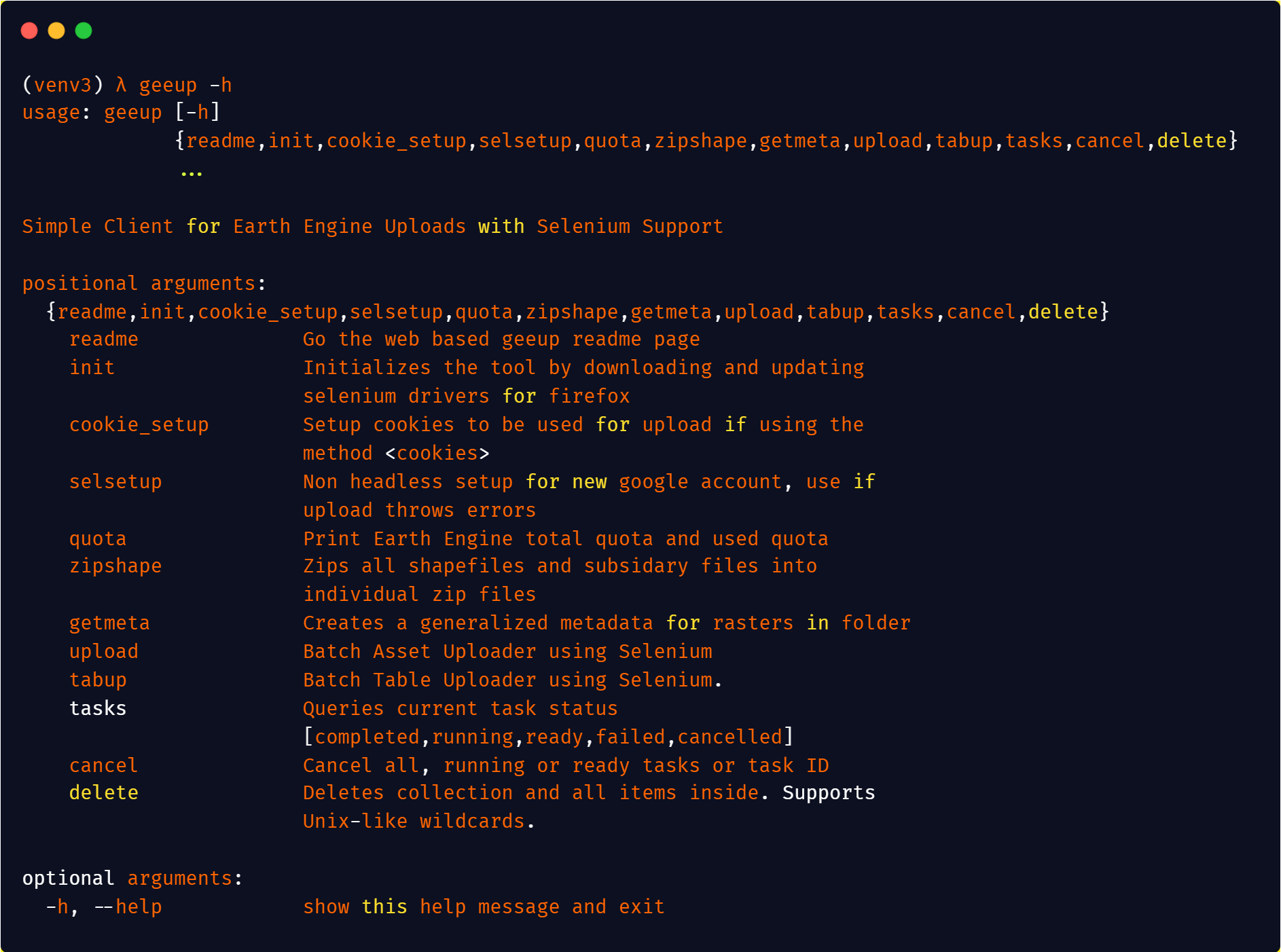
Simple CLI for Google Earth Engine Uploads
geeup: Simple CLI for Earth Engine Uploads with Selenium Support This tool came of the simple need to handle batch uploads of both image assets to col
 79 Nov 26, 2022
Mmdb-server - An open source fast API server to lookup IP addresses for their geographic location
mmdb-server mmdb-server is an open source fast API server to lookup IP addresses
 67 Nov 25, 2022

Daily social mapping project in November 2021. Maps made using PyGMT whenever possible.
Daily social mapping project in November 2021. Maps made using PyGMT whenever possible.
 20 Nov 24, 2022

Build, deploy and extract satellite public constellations with one command line.
SatExtractor Build, deploy and extract satellite public constellations with one command line. Table of Contents About The Project Getting Started Stru
 70 Nov 18, 2022
Obtain a GNSS position fix from an 11-millisecond raw GNSS signal snapshot
Obtain a GNSS position fix from an 11-millisecond raw GNSS signal snapshot without any prior knowledge about the position of the receiver and only coarse knowledge about the time.
 2 Nov 17, 2022

Enable geospatial data mining through Google Earth Engine in Grasshopper 3D, via its most recent Hops component.
AALU_Geo Mining This repository is produced for a masterclass at the Architectural Association Landscape Urbanism programme. Requirements Rhinoceros (
 4 Nov 16, 2022
Python module and script to interact with the Tractive GPS tracker.
pyTractive GPS Python module and script to interact with the Tractive GPS tracker. Requirements Python 3 geopy folium pandas pillow usage: main.py [-h
 3 Nov 16, 2022

Color correction plugin for rasterio
rio-color A rasterio plugin for applying basic color-oriented image operations to geospatial rasters. Goals No heavy dependencies: rio-color is purpos
 111 Nov 15, 2022
iNaturalist observations along hiking trails
This tool reads the route of a hike and generates a table of iNaturalist observations along the trails. It also shows the observations and the route of the hike on a map. Moreover, it saves waypoints of the iNaturalist observations for offline navigation with a GPS device or smartphone.
 7 Nov 11, 2022
GeoIP Legacy Python API
MaxMind GeoIP Legacy Python Extension API Requirements Python 2.5+ or 3.3+ GeoIP Legacy C Library 1.4.7 or greater Installation With pip: $ pip instal
 230 Nov 10, 2022

A GUI widget for Linux to show current time in different timezones.
A GUI widget to show current time in different timezones (under development). To use this widget: Run scripts/startup.py Select a country. A list of t
 11 Nov 10, 2022
geobeam - adds GIS capabilities to your Apache Beam and Dataflow pipelines.
geobeam adds GIS capabilities to your Apache Beam pipelines. What does geobeam do? geobeam enables you to ingest and analyze massive amounts of geospa
 61 Nov 8, 2022
Python module to access the OpenCage geocoding API
OpenCage Geocoding Module for Python A Python module to access the OpenCage Geocoder. Build Status / Code Quality / etc Usage Supports Python 3.6 or n
 57 Nov 1, 2022
Imports VZD (Latvian State Land Service) open data into postgis enabled database
Python script main.py downloads and imports Latvian addresses into PostgreSQL database. Data contains parishes, counties, cities, towns, and streets.
 7 Oct 26, 2022
A NASA MEaSUREs project to provide automated, low latency, global glacier flow and elevation change datasets
Notebooks A NASA MEaSUREs project to provide automated, low latency, global glacier flow and elevation change datasets This repository provides tools
 27 Oct 25, 2022

A short term landscape evolution using a path sampling method to solve water and sediment flow continuity equations and model mass flows over complex topographies.
r.sim.terrain A short-term landscape evolution model that simulates topographic change for both steady state and dynamic flow regimes across a range o
 7 Oct 21, 2022

Django model field that can hold a geoposition, and corresponding widget
django-geoposition A model field that can hold a geoposition (latitude/longitude), and corresponding admin/form widget. Prerequisites Starting with ve
 324 Oct 17, 2022
Python script to locate mobile number
Python script to locate mobile number How to use this script run the command to install the required libraries pip install -r requirements.txt run the
 8 Oct 10, 2022
Pure Python NetCDF file reader and writer
Pyncf Pure Python NetCDF file reading and writing. Introduction Inspired by the pyshp library, which provides simple pythonic and dependency free data
 14 Sep 30, 2022

Google Maps keeps old satellite imagery around for a while – this tool collects what's available for a user-specified region in the form of a GIF.
google-maps-at-88-mph The folks maintaining Google Maps regularly update the satellite imagery it serves its users, but outdated versions of the image
 111 Sep 27, 2022

Python 台灣行政區地圖 (2021)
Python 台灣行政區地圖 (2021) 以 python 讀取政府開放平台的 ShapeFile 地圖資訊。歡迎引用或是協作 另有縣市資訊、村里資訊與各種行政地圖資訊 例如: 直轄市、縣市界線(TWD97經緯度) 鄉鎮市區界線(TWD97經緯度) | 政府資料開放平臺: https://data
 12 Sep 27, 2022

Histogram matching plugin for rasterio
rio-hist Histogram matching plugin for rasterio. Provides a CLI and python module for adjusting colors based on histogram matching in a variety of col
75 Sep 23, 2022
Tools for the extraction of OpenStreetMap street network data
OSMnet Tools for the extraction of OpenStreetMap (OSM) street network data. Intended to be used in tandem with Pandana and UrbanAccess libraries to ex
 47 Sep 21, 2022
Yet Another Time Series Model
Yet Another Timeseries Model (YATSM) master v0.6.x-maintenance Build Coverage Docs DOI | About Yet Another Timeseries Model (YATSM) is a Python packag
 60 Sep 13, 2022
Minimum Bounding Box of Geospatial data
BBOX Problem definition: The spatial data users often are required to obtain the coordinates of the minimum bounding box of vector and raster data in
 1 Sep 8, 2022
Read and write rasters in parallel using Rasterio and Dask
dask-rasterio dask-rasterio provides some methods for reading and writing rasters in parallel using Rasterio and Dask arrays. Usage Read a multiband r
 85 Aug 30, 2022
List of Land Cover datasets in the GEE Catalog
List of Land Cover datasets in the GEE Catalog A list of all the Land Cover (or discrete) datasets in Google Earth Engine. Values, Colors and Descript
 5 Aug 24, 2022
QLUSTER is a relative orbit design tool for formation flying satellite missions and space rendezvous scenarios
QLUSTER is a relative orbit design tool for formation flying satellite missions and space rendezvous scenarios, that I wrote in Python 3 for my own research and visualisation. It is currently unfinished (95%) but the core algorithm and app works. Here's an example snippet of the GUI where four deputy satellites are orbiting a single chief in LEO.
 9 Aug 23, 2022

This is the antenna performance plotted from tinyGS reception data.
tinyGS-antenna-map This is the antenna performance plotted from tinyGS reception data. See their repository. The code produces a plot that provides Az
 14 Aug 21, 2022
Geospatial Image Processing for Python
GIPPY Gippy is a Python library for image processing of geospatial raster data. The core of the library is implemented as a C++ library, libgip, with
 83 Aug 19, 2022

Interactive Maps with Geopandas
Create Interactive maps 🗺️ with your geodataframe Geopatra extends geopandas for interactive mapping and attempts to wrap the goodness of amazing map
 46 Aug 16, 2022
Starlite-tile38 - Showcase using Tile38 via pyle38 in a Starlite application
Starlite-Tile38 Showcase using Tile38 via pyle38 in a Starlite application. Repo
 8 Aug 7, 2022
Expose a GDAL file as a HTTP accessible on-the-fly COG
cogserver Expose any GDAL recognized raster file as a HTTP accessible on-the-fly COG (Cloud Optimized GeoTIFF) The on-the-fly COG file is not material
 73 Aug 4, 2022

How to use COG's (Cloud optimized GeoTIFFs) with Rasterio
How to use COG's (Cloud optimized GeoTIFFs) with Rasterio According to Cogeo.org: A Cloud Opdtimized GeoTIFF (COG) is a regular GeoTIFF file, aimed at
 8 Jul 29, 2022
gpdvega is a bridge between GeoPandas and Altair that allows to seamlessly chart geospatial data
gpdvega gpdvega is a bridge between GeoPandas a geospatial extension of Pandas and the declarative statistical visualization library Altair, which all
 49 Jul 25, 2022
This is a simple python code to get IP address and its location using python
IP address & Location finder @DEV/ED : Pavan Ananth Sharma Dependencies: ip2geotools Note: use pip install ip2geotools to install this in your termin
 2 Jul 5, 2022

Advanced raster and geometry manipulations
buzzard In a nutshell, the buzzard library provides powerful abstractions to manipulate together images and geometries that come from different kind o
 30 Jun 20, 2022
Logging the position of the car on an sdcard
audi-mmi-3g-gps-logging Logging the position of the car on an sdcard, startup script origin not clear to me, logging setup and time change is what I d
 2 May 31, 2022

Example of animated maps in matplotlib + geopandas using entire time series of congressional district maps from UCLA archive. rendered, interactive version below
Example of animated maps in matplotlib + geopandas using entire time series of congressional district maps from UCLA archive. rendered, interactive version below
 5 May 18, 2022

Extract GoPro highlights and GPMF data.
Python script that parses the gpmd stream for GOPRO moov track (MP4) and extract the GPS info into a GPX (and kml) file.
 2 May 13, 2022
Using Global fishing watch's data to build a machine learning model that can identify illegal fishing and poaching activities through satellite and geo-location data.
Using Global fishing watch's data to build a machine learning model that can identify illegal fishing and poaching activities through satellite and geo-location data.
 3 May 6, 2022

Python script that can be used to generate latitude/longitude coordinates for GOES-16 full-disk extent.
goes-latlon Python script that can be used to generate latitude/longitude coordinates for GOES-16 full-disk extent. 🌎 🛰️ The grid files can be acces
 3 Apr 6, 2022

A service to auto provision devices in Aruba Central based on the Geo-IP location
Location Based Provisioning Service for Aruba Central A service to auto provision devices in Aruba Central based on the Geo-IP location Geo-IP auto pr
 3 Mar 22, 2022
Evaluation of file formats in the context of geo-referenced 3D geometries.
Geo-referenced Geometry File Formats Classic geometry file formats as .obj, .off, .ply, .stl or .dae do not support the utilization of coordinate syst
 11 Mar 2, 2022
Program that shows all the details of the given IP address. Build with Python and ipinfo.io API
ip-details This is a program that shows all the details of the given IP address. Build with Python and ipinfo.io API Usage To use this program, run th
 4 Mar 1, 2022

An API built to format given addresses using Python and Flask.
An API built to format given addresses using Python and Flask. About The API returns properly formatted data, i.e. removing duplicate fields, distingu
 1 Feb 27, 2022
Get-countries-info - A python code that fetches data of any country
Country-info A python code getting countries information including country's map
 2 Feb 21, 2022

This program analizes films database with adresses, and creates a folium map with closest films to the coordinates
Films-map-project UCU CS lab 1.2, 1st year This program analizes films database with adresses, and creates a folium map with closest films to the coor
 1 Feb 9, 2022

This repository contains the scripts to derivate the ENU and ECEF coordinates from the longitude, latitude, and altitude values encoded in the NAD83 coordinates.
This repository contains the scripts to derivate the ENU and ECEF coordinates from the longitude, latitude, and altitude values encoded in the NAD83 coordinates.
 1 Feb 7, 2022
Creates 3D geometries from 2D vector graphics, for use in geodynamic models
geomIO - creating 3D geometries from 2D input This is the Julia and Python version of geomIO, a free open source software to generate 3D volumes and s
 3 Feb 1, 2022

LicenseLocation - License Location With Python
LicenseLocation Hi,everyone! ❤ 🧡 💛 💚 💙 💜 This is my first project! ✔ Actual
 1 Jan 25, 2022

Script that allows to download data with satellite's orbit height and create CSV with their change in time.
Satellite orbit height ◾ Requirements Python = 3.8 Packages listen in reuirements.txt (run pip install -r requirements.txt) Account on Space Track ◾
 2 Jan 17, 2022

A public data repository for datasets created from TransLink GTFS data.
TransLink Spatial Data What: TransLink is the statutory public transit authority for the Metro Vancouver region. This GitHub repository is a collectio
 3 Jan 14, 2022

Python project to generate Kerala's distrcit level panchayath map.
Kerala-Panchayath-Maps Python project to generate Kerala's distrcit level panchayath map. As of now, geojson files of Kollam and Kozhikode are added t
 2 Jan 10, 2022