87 Repositories
Python satellite-orbit-height Libraries

PyTorch implementation of U-TAE and PaPs for satellite image time series panoptic segmentation.
Panoptic Segmentation of Satellite Image Time Series with Convolutional Temporal Attention Networks (ICCV 2021) This repository is the official implem
🛰️ List of earth observation companies and job sites
Earth Observation Companies & Jobs source Portals & Jobs Geospatial Geospatial jobs newsletter: ~biweekly newsletter with geospatial jobs by Ali Ahmad

moving object detection for satellite videos.
DSFNet: Dynamic and Static Fusion Network for Moving Object Detection in Satellite Videos Algorithm Introduction DSFNet: Dynamic and Static Fusion Net

SatelliteNeRF - PyTorch-based Neural Radiance Fields adapted to satellite domain
SatelliteNeRF PyTorch-based Neural Radiance Fields adapted to satellite domain.

A particular navigation route using satellite feed and can help in toll operations & traffic managemen
How about adding some info that can quanitfy the stress on a particular navigation route using satellite feed and can help in toll operations & traffic management The current analysis is on the satellite image frame, but if we can add this info to a live feed it can help in developing smoother navigation systems based on real time traffic scenario

Multi-Object Tracking in Satellite Videos with Graph-Based Multi-Task Modeling
TGraM Multi-Object Tracking in Satellite Videos with Graph-Based Multi-Task Modeling, Qibin He, Xian Sun, Zhiyuan Yan, Beibei Li, Kun Fu Abstract Rece
Automatically measure the facial Width-To-Height ratio and get facial analysis results provided by Microsoft Azure
fwhr-calc-website This project is to automatically measure the facial Width-To-Height ratio and get facial analysis results provided by Microsoft Azur

YOLTv5 rapidly detects objects in arbitrarily large aerial or satellite images that far exceed the ~600×600 pixel size typically ingested by deep learning object detection frameworks
YOLTv5 rapidly detects objects in arbitrarily large aerial or satellite images that far exceed the ~600×600 pixel size typically ingested by deep learning object detection frameworks.

SatelliteSfM - A library for solving the satellite structure from motion problem
Satellite Structure from Motion Maintained by Kai Zhang. Overview This is a libr
🌍 Create 3d-printable STLs from satellite elevation data 🌏
mapa 🌍 Create 3d-printable STLs from satellite elevation data Installation pip install mapa Usage mapa uses numpy and numba under the hood to crunch
Predicting a person's gender based on their weight and height
Logistic Regression Advanced Case Study Gender Classification: Predicting a person's gender based on their weight and height 1. Introduction We turn o
The NEOSSat is a dual-mission microsatellite designed to detect potentially hazardous Earth-orbit-crossing asteroids and track objects that reside in deep space
The NEOSSat is a dual-mission microsatellite designed to detect potentially hazardous Earth-orbit-crossing asteroids and track objects that reside in deep space

An introduction to satellite image analysis using Python + OpenCV and JavaScript + Google Earth Engine
A Gentle Introduction to Satellite Image Processing Welcome to this introductory course on Satellite Image Analysis! Satellite imagery has become a pr

Python script that can be used to generate latitude/longitude coordinates for GOES-16 full-disk extent.
goes-latlon Python script that can be used to generate latitude/longitude coordinates for GOES-16 full-disk extent. 🌎 🛰️ The grid files can be acces
Python scripts for semi-automated morphometric analysis of atolls from Landsat satellite Imagery.
AtollGeoMorph Python scripts for semi-automated morphometric analysis of atolls from Landsat satellite Imagery. The python scripts included allow user
Kaggle DSTL Satellite Imagery Feature Detection
Kaggle DSTL Satellite Imagery Feature Detection

Raster Vision is an open source Python framework for building computer vision models on satellite, aerial, and other large imagery sets
Raster Vision is an open source Python framework for building computer vision models on satellite, aerial, and other large imagery sets (including obl

Generic ecosystem for feature extraction from aerial and satellite imagery
Note: Robosat is neither maintained not actively developed any longer by Mapbox. See this issue. The main developers (@daniel-j-h, @bkowshik) are no l

🛰️ Awesome Satellite Imagery Datasets
Awesome Satellite Imagery Datasets List of aerial and satellite imagery datasets with annotations for computer vision and deep learning. Newest datase

Modeling and Simulation of Satellite Servicing Manipulators
Modeling and Simulation of Satellite Servicing Manipulators Final Project for the course ENPM662: Introduction to Robot Modeling (Fall 2021). This pro
Connects to an active BitCoin Peer and communicates in order to locate a specific block number (height)
BitCoin-Peer-Client Connects to an active BitCoin Peer, and locates a predetermined block number (height) by downloading block headers. Once required
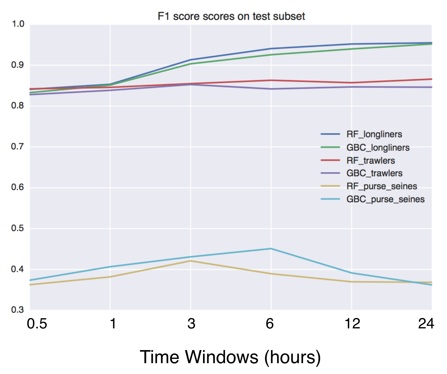
Using Global fishing watch's data to build a machine learning model that can identify illegal fishing and poaching activities through satellite and geo-location data.
Using Global fishing watch's data to build a machine learning model that can identify illegal fishing and poaching activities through satellite and geo-location data.

Download and process GOES-16 and GOES-17 data from NOAA's archive on AWS using Python.
Download and display GOES-East and GOES-West data GOES-East and GOES-West satellite data are made available on Amazon Web Services through NOAA's Big

Script that allows to download data with satellite's orbit height and create CSV with their change in time.
Satellite orbit height ◾ Requirements Python = 3.8 Packages listen in reuirements.txt (run pip install -r requirements.txt) Account on Space Track ◾

A ninja python package that unifies the Google Earth Engine ecosystem.
A Python package that unifies the Google Earth Engine ecosystem. EarthEngine.jl | rgee | rgee+ | eemont GitHub: https://github.com/r-earthengine/ee_ex
Space robot - (Course Project) Using the space robot to capture the target satellite that is disabled and spinning, then stabilize and fix it up
Space robot - (Course Project) Using the space robot to capture the target satellite that is disabled and spinning, then stabilize and fix it up

To dynamically change the split direction in I3/Sway so as to split new windows automatically based on the width and height of the focused window
To dynamically change the split direction in I3/Sway so as to split new windows automatically based on the width and height of the focused window Insp

To propose and implement a multi-class classification approach to disaster assessment from the given data set of post-earthquake satellite imagery.
To propose and implement a multi-class classification approach to disaster assessment from the given data set of post-earthquake satellite imagery.
Calculate & view the trajectory and live position of any earth-orbiting satellite
satellite-visualization A cross-platform application to calculate & view the trajectory and live position of any earth-orbiting satellite in 3D. This
Height 2 LDraw With python
Height2Ldraw About This project aims to be able to make a full lego 3D model using the ldraw file format (.ldr) from a height and color map, currently

CoANet: Connectivity Attention Network for Road Extraction From Satellite Imagery
CoANet: Connectivity Attention Network for Road Extraction From Satellite Imagery This paper (CoANet) has been published in IEEE TIP 2021. This code i

A Semantic Segmentation Network for Urban-Scale Building Footprint Extraction Using RGB Satellite Imagery
A Semantic Segmentation Network for Urban-Scale Building Footprint Extraction Using RGB Satellite Imagery This repository is the official implementati

Marine debris detection with commercial satellite imagery and deep learning.
Marine debris detection with commercial satellite imagery and deep learning. Floating marine debris is a global pollution problem which threatens mari

A Transformer-Based Feature Segmentation and Region Alignment Method For UAV-View Geo-Localization
University1652-Baseline [Paper] [Slide] [Explore Drone-view Data] [Explore Satellite-view Data] [Explore Street-view Data] [Video Sample] [中文介绍] This

A python package that extends Google Earth Engine.
A python package that extends Google Earth Engine GitHub: https://github.com/davemlz/eemont Documentation: https://eemont.readthedocs.io/ PyPI: https:

🌾 PASTIS 🌾 Panoptic Agricultural Satellite TIme Series
🌾 PASTIS 🌾 Panoptic Agricultural Satellite TIme Series (optical and radar) The PASTIS Dataset Dataset presentation PASTIS is a benchmark dataset for

Centroid-UNet is deep neural network model to detect centroids from satellite images.
Centroid UNet - Locating Object Centroids in Aerial/Serial Images Introduction Centroid-UNet is deep neural network model to detect centroids from Aer
A Python library for loading data from a SpaceX Starlink satellite.
Starlink Python A Python library for loading data from a SpaceX Starlink satellite. The goal is to be a simple interface for Starlink. It builds upon
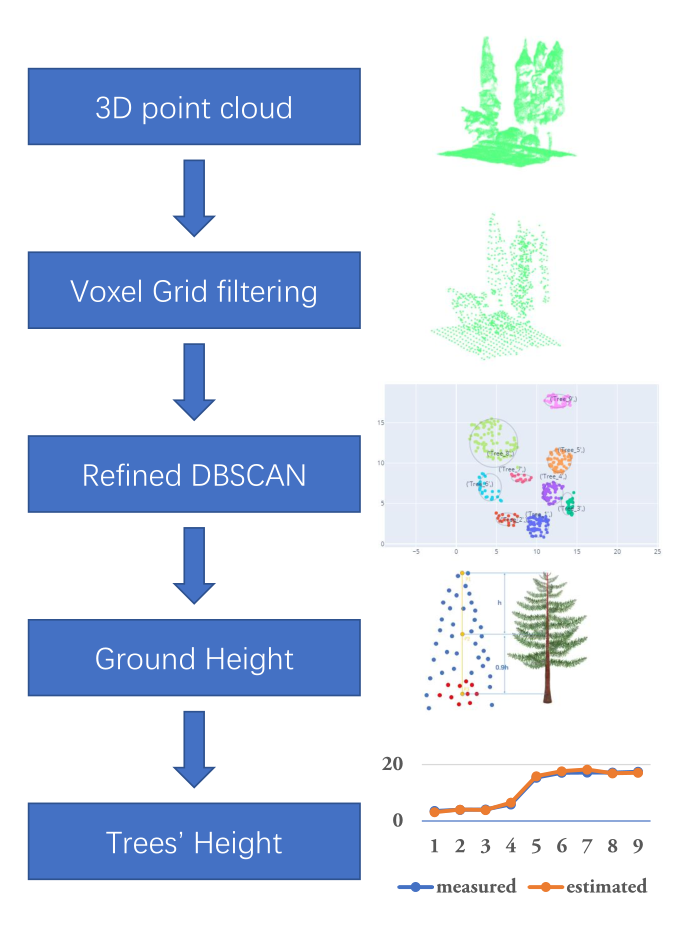
A simple algorithm for extracting tree height in sparse scene from point cloud data.
TREE HEIGHT EXTRACTION IN SPARSE SCENES BASED ON UAV REMOTE SENSING This is the offical python implementation of the paper "Tree Height Extraction in
Earth-to-orbit ballistic trajectories with atmospheric resistance
Earth-to-orbit ballistic trajectories with atmospheric resistance Overview Space guns are a theoretical technology that reduces the cost of getting bu
NEO: Non Equilibrium Sampling on the orbit of a deterministic transform
NEO: Non Equilibrium Sampling on the orbit of a deterministic transform Description of the code This repo describes the NEO estimator described in the

🛰️ Scripts démontrant l'utilisation de l'imagerie RADARSAT-1 à partir d'un seau AWS | 🛰️ Scripts demonstrating the use of RADARSAT-1 imagery from an AWS bucket
🛰️ Scripts démontrant l'utilisation de l'imagerie RADARSAT-1 à partir d'un seau AWS | 🛰️ Scripts demonstrating the use of RADARSAT-1 imagery from an AWS bucket

Detecting and Tracking Small and Dense Moving Objects in Satellite Videos: A Benchmark
This dataset is a large-scale dataset for moving object detection and tracking in satellite videos, which consists of 40 satellite videos captured by Jilin-1 satellite platforms.

🗂️ 🔍 Geospatial Data Management and Search API - Django Apps
Geospatial Data API in Django Resonant GeoData (RGD) is a series of Django applications well suited for cataloging and searching annotated geospatial

Implementation of the pix2pix model on satellite images
This repo shows how to implement and use the pix2pix GAN model for image to image translation. The model is demonstrated on satellite images, and the
A package to fetch sentinel 2 Satellite data from Google.
Sentinel 2 Data Fetcher Installation Create a Virtual Environment and activate it. python3 -m venv venv . venv/bin/activate Install the Package via pi

LEOGPS - Satellite Navigation with GPS on Python!
LEOGPS is an open-source Python software which performs relative satellite navigation between two formation flying satellites, with the objective of high accuracy relative positioning. Specifically, LEOGPS solves for the double-differenced baseline (using float ambiguity resolution) between satellites flying in formation in Low Earth Orbit (LEO).

code for paper -- "Seamless Satellite-image Synthesis"
Seamless Satellite-image Synthesis by Jialin Zhu and Tom Kelly. Project site. The code of our models borrows heavily from the BicycleGAN repository an
Earth centric orbit propagation tool. Built from scratch in python.
Orbit-Propogator Earth centric orbit propagation tool. Built from scratch in python. Functionality includes: tracking sattelite location over time plo
Python tools for working with Orbit Ephemeris Messages (OEMs).
Python Orbit Ephemeris Message tools Python tools for working with Orbit Ephemeris Messages (OEMs). Development Status Installation The oem package is
A method to perform unsupervised cross-region adaptation of crop classifiers trained with satellite image time series.
TimeMatch Official source code of TimeMatch: Unsupervised Cross-region Adaptation by Temporal Shift Estimation by Joachim Nyborg, Charlotte Pelletier,
This is a simple python flask web app that implements geometric calculations for three shapes given the user's input for radius and height. It is recommended this app be run using a python virtual environment, but not necessary for success. Unit tests are also included.
Geometry Calculator Web The is a simple Flask-based web application that uses a Geometry Calculator Tool created out of assignments from my Intro to P
Multiband spectro-radiometric satellite image analysis with K-means cluster algorithm
Multi-band Spectro Radiomertric Image Analysis with K-means Cluster Algorithm Overview Multi-band Spectro Radiomertric images are images comprising of
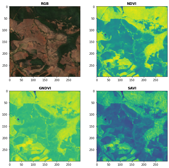
Awesome Spectral Indices in Python.
Awesome Spectral Indices in Python: Numpy | Pandas | GeoPandas | Xarray | Earth Engine | Planetary Computer | Dask GitHub: https://github.com/davemlz/

Automatic picture transmission(APT) protocol decoder for NOAA weather satellites
Automatic picture transmission(APT) decoder Automatic picture transmission protocol is used by NOAA satellites. They constantly send a frequency modul

A simple python script that, given a location and a date, uses the Nasa Earth API to show a photo taken by the Landsat 8 satellite. The script must be executed on the command-line.
What does it do? Given a location and a date, it uses the Nasa Earth API to show a photo taken by the Landsat 8 satellite. The script must be executed

Build, deploy and extract satellite public constellations with one command line.
SatExtractor Build, deploy and extract satellite public constellations with one command line. Table of Contents About The Project Getting Started Stru
EODAG is a command line tool and a plugin-oriented Python framework for searching, aggregating results and downloading remote sensed images while offering a unified API for data access regardless of the data provider
EODAG (Earth Observation Data Access Gateway) is a command line tool and a plugin-oriented Python framework for searching, aggregating results and downloading remote sensed images while offering a unified API for data access regardless of the data provider

Amazon Forest Computer Vision: Satellite Image tagging code using PyTorch / Keras with lots of PyTorch tricks
Amazon Forest Computer Vision Satellite Image tagging code using PyTorch / Keras Here is a sample of images we had to work with Source: https://www.ka
missing-pixel-filler is a python package that, given images that may contain missing data regions (like satellite imagery with swath gaps), returns these images with the regions filled.
Missing Pixel Filler This is the official code repository for the Missing Pixel Filler by SpaceML. missing-pixel-filler is a python package that, give
A 2D physics sim for orbits. Made using pygame and tkinter. High degree of intractability, allowing you to create celestial bodies of a custom mass and velocity within the simulation, select what specifically is displayed, and move the camera.
Python-Orbit-Sim A 2D physics sim for orbits. Made using pygame and tkinter. High degree of intractability, allowing you to create celestial bodies of
Blender addon to generate better building models from satellite imagery.
Blender addon to generate better building models from satellite imagery.

Satellite labelling tool for manual labelling of storm top features such as overshooting tops, above-anvil plumes, cold U/Vs, rings etc.
Satellite labelling tool About this app A tool for manual labelling of storm top features such as overshooting tops, above-anvil plumes, cold U/Vs, ri
Train a deep learning net with OpenStreetMap features and satellite imagery.
DeepOSM Classify roads and features in satellite imagery, by training neural networks with OpenStreetMap (OSM) data. DeepOSM can: Download a chunk of

A ready-to-use curated list of Spectral Indices for Remote Sensing applications.
A ready-to-use curated list of Spectral Indices for Remote Sensing applications. GitHub: https://github.com/davemlz/awesome-ee-spectral-indices Docume

Script de monitoramento de telemetria para missões espaciais, cansat e foguetemodelismo.
Aeroespace_GroundStation Script de monitoramento de telemetria para missões espaciais, cansat e foguetemodelismo. Imagem 1 - Dashboard realizando moni

Google Maps keeps old satellite imagery around for a while – this tool collects what's available for a user-specified region in the form of a GIF.
google-maps-at-88-mph The folks maintaining Google Maps regularly update the satellite imagery it serves its users, but outdated versions of the image

1st place solution to the Satellite Image Change Detection Challenge hosted by SenseTime
1st place solution to the Satellite Image Change Detection Challenge hosted by SenseTime

Amazon Forest Computer Vision: Satellite Image tagging code using PyTorch / Keras with lots of PyTorch tricks
Amazon Forest Computer Vision Satellite Image tagging code using PyTorch / Keras Here is a sample of images we had to work with Source: https://www.ka

A large dataset of 100k Google Satellite and matching Map images, resembling pix2pix's Google Maps dataset.
Larger Google Sat2Map dataset This dataset extends the aerial ⟷ Maps dataset used in pix2pix (Isola et al., CVPR17). The provide script download_sat2m

Monorepo for my Raspberry Pi dashboard and GPS satellite listener.
🥧 pi dashboard My blog post: Listening to Satellites with my Raspberry Pi This is the monorepo for my Raspberry Pi dashboard!

QLUSTER is a relative orbit design tool for formation flying satellite missions and space rendezvous scenarios
QLUSTER is a relative orbit design tool for formation flying satellite missions and space rendezvous scenarios, that I wrote in Python 3 for my own research and visualisation. It is currently unfinished (95%) but the core algorithm and app works. Here's an example snippet of the GUI where four deputy satellites are orbiting a single chief in LEO.
EOReader is a multi-satellite reader allowing you to open optical and SAR data.
Remote-sensing opensource python library reading optical and SAR sensors, loading and stacking bands, clouds, DEM and index.
Xarray backend to Copernicus Sentinel-1 satellite data products
xarray-sentinel WARNING: this product is a "technology preview" / pre-Alpha Xarray backend to explore and load Copernicus Sentinel-1 satellite data pr
Download and process satellite imagery in Python using Sentinel Hub services.
Description The sentinelhub Python package allows users to make OGC (WMS and WCS) web requests to download and process satellite images within your Py
Satellite imagery for dummies.
felicette Satellite imagery for dummies. What can you do with this tool? TL;DR: Generate JPEG earth imagery from coordinates/location name with public
framework for large-scale SAR satellite data processing
pyroSAR A Python Framework for Large-Scale SAR Satellite Data Processing The pyroSAR package aims at providing a complete solution for the scalable or
Stitch image tiles into larger composite TIFs
untiler Utility to take a directory of {z}/{x}/{y}.(jpg|png) tiles, and stitch into a scenetiff (tif w/ exact merc tile bounds). Future versions will
Cloud Optimized GeoTIFF creation and validation plugin for rasterio
rio-cogeo Cloud Optimized GeoTIFF (COG) creation and validation plugin for Rasterio. Documentation: https://cogeotiff.github.io/rio-cogeo/ Source Code

User friendly Rasterio plugin to read raster datasets.
rio-tiler User friendly Rasterio plugin to read raster datasets. Documentation: https://cogeotiff.github.io/rio-tiler/ Source Code: https://github.com

Color correction plugin for rasterio
rio-color A rasterio plugin for applying basic color-oriented image operations to geospatial rasters. Goals No heavy dependencies: rio-color is purpos

Histogram matching plugin for rasterio
rio-hist Histogram matching plugin for rasterio. Provides a CLI and python module for adjusting colors based on histogram matching in a variety of col
A utility to search, download and process Landsat 8 satellite imagery
Landsat-util Landsat-util is a command line utility that makes it easy to search, download, and process Landsat imagery. Docs For full documentation v
Search and download Copernicus Sentinel satellite images
sentinelsat Sentinelsat makes searching, downloading and retrieving the metadata of Sentinel satellite images from the Copernicus Open Access Hub easy
Python package for earth-observing satellite data processing
Satpy The Satpy package is a python library for reading and manipulating meteorological remote sensing data and writing it to various image and data f
Rasterio reads and writes geospatial raster datasets
Rasterio Rasterio reads and writes geospatial raster data. Geographic information systems use GeoTIFF and other formats to organize and store gridded,
Code and model benchmarks for "SEVIR : A Storm Event Imagery Dataset for Deep Learning Applications in Radar and Satellite Meteorology"
NeurIPS 2020 SEVIR Code for paper: SEVIR : A Storm Event Imagery Dataset for Deep Learning Applications in Radar and Satellite Meteorology Requirement